Story
 April 17, 2020
How the ‘Orange Areas’ Dispute in Central India Leaves Dalit, Adivasi Farmers Without Land Rights
Country:

Over 1.5 million people in central India live in the crossfire of a 50-year old land dispute between...

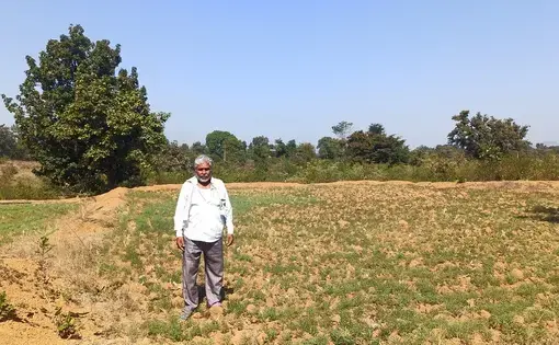
Betul (Madhya Pradesh): Ramsingh Nagvanshi has never considered himself a forest dweller. He lives in Katangi village in Central India’s Betul district where, like most farmers of the region, he grows paddy in the monsoon and wheat and chickpea in the winter. His village is typical of central Indian plains with vast farmlands, undulating open areas for grazing, and a clear view to the horizon. 55-year-old Ramsingh, who is Dalit, points to his five-acre patch of chickpea and said, “I do not understand how this can be a forest?”
However, Ramsingh’s land, his only source of livelihood, is classified as a forest in government records, and he doesn’t have title over it. That is because it falls in orange areas – disputed lands over which both the forest and the revenue departments of the state have been exerting control for many decades. These lands are called “orange areas” because of an old, unverified story that they were coloured orange on government maps.
This bureaucratic battle has left an estimated 1.5 million people, including Ramsingh, feeling anxious and insecure in central India’s Madhya Pradesh and Chhattisgarh states. The dispute covers 36,000 villages and 70% of the districts, including Betul, in Madhya Pradesh alone. The state governments have been unable to resolve the issue because the messy data on orange areas is old and spread across dozens of district offices, and untangling it would require resources and time that local administrations say they do not have.
The fear that the government might evict him at any time from his farm recently drove Ramsingh to identify himself as a forest dweller under India’s forest rights law, so that he gets title to his land.
While he awaits the forest title, the Madhya Pradesh government formed a task force last year to find solutions to the problem. The task force submitted its report this February and the details of the recommendations are not known because the report has not been made public yet. But broadly it has developed a set of solutions within the framework of laws on forests and land rights, said Rohini Chaturvedi, an independent consultant and a non-official member of the task force. Chaturvedi had led a project by World Resources Institute-India or WRI-India, a research organisation, on orange areas.
“Never before have I felt more optimistic that there will be action on the ground,” Chaturvedi said. The WRI-India project, which concluded in 2018, put together information on orange areas from district-level offices into a database that can help the government resolve the problem.
Secure tenure and resource rights help catalyse investment in farming and strengthen livelihoods while ambiguity constraints such as household-level decision making, mentions a note that was prepared by WRI-India.
Origin of the dispute
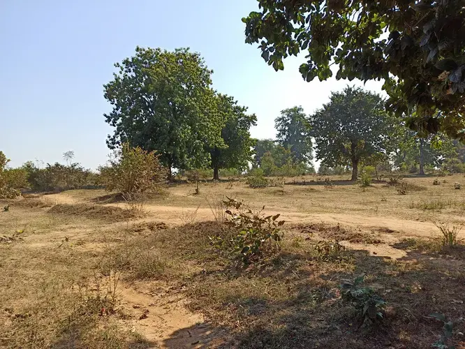
In January this year, Ramsingh’s rectangular farm plot bore a foot- high winter crop of chickpea within its waist-high bunds. On one side there was a small stream, from which he drew water using a diesel-powered pump. The small farm gave way to undulating terrain on the other three sides. Mahua trees shaded sparse grass and small shrubs. There was no sound, except the calls of birds that circled over the trees and occasionally landed to drink from nearby ponds.
This land is a part of the village commons, governance of which is at the centre of the orange areas issue.
Before India was a free country, village land was controlled by feudal landlords known as Malguzars and Zamindars. The lands included private agricultural land, and also the vast common areas that were used for grazing, collecting firewood and wood for building homes. The Malguzars allowed small parts of this common land to be cultivated by landless communities such as Dalits and Adivasis, who grew food crops.
After India’s independence, the Malguzar-Zamindar system was abolished. The control of village land went to the revenue department. Because some of these lands had tree cover, the state of Madhya Pradesh issued orders in the 1950s that notified all village commons as protected forests. It then ordered a field survey to identify the land under cultivation and isolated patches which could not be monitored by the forests department, and leave these out of the protected forests area. The government would then in 1970s issue orders to ‘de-notify’ these areas and transfer them to the revenue department. Both the forest and revenue departments were then meant to correct their records to show the changes. This process, however, was never finished.
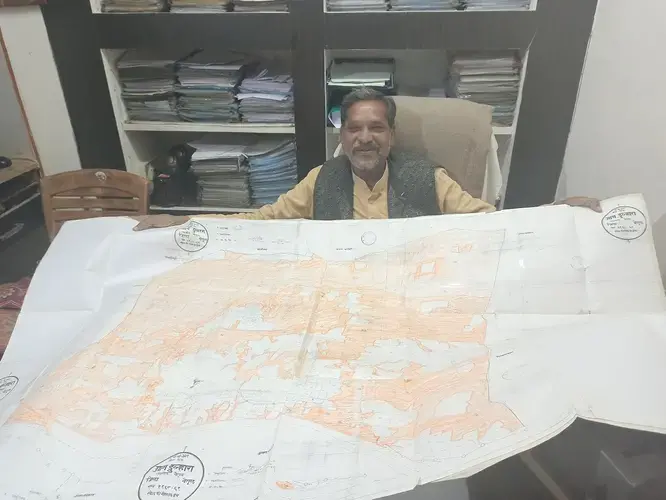
“There is not a single village where this has been resolved,” said Anil Garg, a 64-year-old lawyer in Betul town, who has spent more than 30 years unearthing the extent of the problem from dusty record-storage rooms of revenue and forest offices. A lean, bearded man with a ready smile, Garg has been informing farmers like Ramsingh about the orange areas dispute, and lobbies government officials to find remedies.
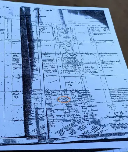
Village-level land records accessed by Garg and Ramsingh show the extent of the problem. In Katangi, about 1300 acres of land was notified as protected forests in the 1950s. During the field survey in the 1960s, 113 acres were recommended to be de-notified, as they were either under cultivation or were in isolated patches.
In 1970, before the de-notification could be completed, the Madhya Pradesh government handed out leases to farmers over 111 acres of farmland which were already under cultivation. Ramsingh’s father Mandari Nagvanshi was one of the lessees. In 1975 the state government decided to convert these leases into titles. A land title would formalize lessees’ control over the land, ensure they are never evicted, and allow them to be officially recognized as farmers and receive benefits and subsidies. But because de-notification was never completed, farmers like Nagvanshi didn’t get the titles to the land that his family has depended on for generations. Garg found that only six acres were de-notified in Katangi village. The rest, including Nagvanshi’s farm, remained legally classified as protected forest.
Because the revenue department had handed out leases, it believed the land was under its control. After the leases expired, it penalised farmers for unauthorised use of government land.
Ramsingh took me on his motorcycle to his house. There, he took out a set of laminated documents from a faded plastic bag. The records begin with a copy of documents transferring all the village commons controlled by malguzars to the state government. Another laminated sheet lists Mandari as among the people prosecuted by the revenue department for “encroachment on government land”. A barely legible, hand-written scrawl mentions Mandari’s name, his caste, his case number and a fine of a few rupees. Around that time, Mandari was already growing millet on 10 acres of commons to support his wife and seven children, including Ramsingh. Being a Dalit family from a former ‘untouchable’ caste, the Nagvanshis were historically kept away from owning land.
Mandari was also fined by the forest department and often got into scuffles with the forest guards, Ramsingh remembers. “My father fought a lot with the forest-wallahs to retain the land,” he said. “It was a question of our survival.”
Ramsingh remembers that when he was about 20 years old, a revenue official visited the village to collect everyone’s lease documents, and promised to return with the title documents. But he never came back. When some of the farmers went up to the local revenue office 12 kilometres away, they were told that the official had been transferred, that their leases had expired, and that they were ineligible for land titles – because their farms were on forest land.
Lack of land title has prevented him and his family from accessing government benefits. For instance, the government buys rice and wheat from farmers at good rates, and also provides subsidised fertilisers but those farmers should have land titles. Families like Ramsingh’s are excluded from the system. He sells grain to traders for 30% less and buys fertiliser from the black market at double the subsidised rates. He also cannot apply for agricultural loans from banks and relies on moneylenders.
According to data compiled by Anil Garg, across Madhya Pradesh and Chhattisgarh, 5.8 lakh hectares of land was transferred to the revenue department, but it was not de-notified from forest status to revenue.
Land records mess
Katangi represents just one part of the ‘Orange Areas’ problem. In its neighbouring village Dulhara, all the protected forests were de-notified by the government, but the land records were never updated to reflect that change. So that land still shows up as forest land. In 27,000 villages across Madhya Pradesh, all the protected forests were de-notified, but it is not clear how many of those records were actually updated.
The extent of the dispute also shows up in aggregate figures of forest land in Madhya Pradesh and Chhattisgarh. The forest department and the revenue department report different figures of the area under forests in the state. The figure quoted by the forest department exceeds the figure quoted by the revenue department by 12 lakh hectares, according to a 1994 government brief. The difference is equal to 20 times the area of Mumbai city. The WRI-India project followed this calculation to say that the orange areas dispute covers 1.2 million hectares. But Garg said that the actual disputed figure is at least three times as much.
He points to a different source of data: the total land under the jurisdiction of the forest and revenue departments. Under India’s land regulation system, land can either be under the jurisdiction of the forest or revenue department. The sum of the area under the jurisdiction of each department should be equal to the geographical area of the state. But in Madhya Pradesh, this is not the case. In 1999, the last year that Madhya Pradesh and Chhattisgarh were the same state, the area under the jurisdiction of each of the two departments totalled 3.8 million hectares more than the geographical area of the state, which points to errors in recording and updating land area by both the departments. So this is the extent of land over which both claim jurisdiction, Garg said.
The failure of the forest and revenue departments to de-notify lands, update records and to ensure on-ground transfer of power from forest to revenue department lies “at the heart” of the orange areas issue, said Chaturvedi.
The process should have been completed in the 1970s, when the Madhya Pradesh government had decided to convert farm leases to titles, she said. “Over time, the issue has become more and more complex. We’ve lost track of records, districts have changed, village and plot numbers have changed, and in some instances village maps have also been altered,” said Chaturvedi.
Original land records and forest area documents, which were handed over to state government officials, have disappeared since, according to the 1994 note.
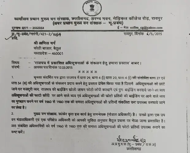
The government of Madhya Pradesh and Chhattisgarh are unable to locate many de-notification orders from the 1960s, and both have written to Garg asking for copies.
In 2004, Madhya Pradesh’s chief secretary, the most senior official to whom both revenue and forest departments report, issued orders to resolve the “orange area” dispute within six months. Nothing happened.
To settle the dispute, officials will need to look at historical records for all 3.8 million hectares of land to verify which lands were recommended to be de-notified in the 1960s, and whether they were, indeed, de-notified. To hand out titles to cultivators like Ramsingh, the officials would have to compare handwritten records from the 1970s with findings from field surveys to verify that present-day cultivators are heirs of the people who had received the leases. They will need to make changes to village-level land records and forest block information.
“We need to work on a mission mode and dedicate all our resources to complete the task, like we do in elections,” said Betul district collector Tejaswi Naik.
Even forest officials want an end to this messy dispute. Puneet Goyal, the forest department officer in charge of half of the Betul district, said that under the state’s rules, if a tree is illegally cut in a forest area, its lifetime economic value is deducted from the salaries of local forest staff. This includes trees in the orange areas where communities cut trees on farmlands, and which were supposed to be left out of the protected forest area. “I’ll be the happiest if the problem is solved,” said Goyal.
“A betrayal”
Perhaps the biggest library of documents tracing the orange areas dispute is a tiny, windowless room behind an eyewear shop in Betul’s main bazaar – Anil Garg’s office.
Garg has a family connection to the issue. Garg’s father was the Malguzar of a few villages near Betul. In the 1980s, he asked Garg, who had recently finished law school, to check on the family land that was taken away after the abolition of the Malguzar system. Malguzars were told that their lands would be divided among the landless. “Instead they gave the land to the forest department and created this mess,” said Garg. “It was a betrayal.”
Garg has given up his legal practice and spends his time lobbying and advising government officials, so that farmers like Ramsingh get land rights. All the officials, journalists, lawyers and researchers working on the problem that I met learnt intricacies of orange areas from him.
But years of government inaction have made him impatient. When the state government in 2015 asked him for copies of the government orders from 1950s, he refused to send them because the government had also asked him for an estimate of the copying charges. “How dare they put a price on the problem?” he snapped, when I asked him why.
Yet, he remains the only hope for villagers like Ramsingh, who fall at his feet and call him Kakaji – a Hindi word for uncle. “It is difficult to understand this whole issue,” Ramsingh told me. “But we are relying on Kakaji to show us the way.”
Desperate moves
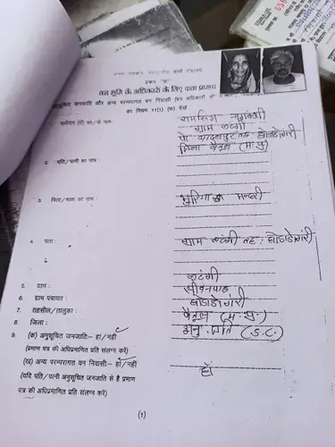
In 2016, on Garg’s advice and because his land is recorded as forest land, Ramsingh and 112 others from his village filed paperwork for land titles under the Forest Rights Act (FRA). The FRA gives land rights in forests to traditional forest dwellers including indigenous peoples or Adivasis. Those who are not Adivasis – such as Dalits – are termed by the law as ‘Other Traditional Forest Dwellers’, and can get the title if they show evidence of living in and depending on the forest land for at least 75 years before December 13, 2005, the day the law was first introduced in Parliament.
Ramsingh and 100 other applicants from his village belong to Dalit and Other Backward Class communities. So, they have filed applications as ‘Other Traditional Forest Dwellers’, but none have documentary evidence going back 75 years. Their applications were rejected by the block-level forest rights committee in 2017 for this reason.
That rejection made them liable to be evicted from their land two years later, in February 2019, when the Supreme Court, which was hearing a petition challenging the FRA, issued an order to all the states to immediately evict people whose FRA applications had been rejected – about 1.3 million families. After a public outcry and intervention by Adivasi rights organisations, the court suspended its order in the same month and asked the states to review all the rejections. The case is still on.
Towards resolution
In December 2018, a new Congress party-led government was voted to power in Madhya Pradesh by defeating Bharatiya Janata Party that ruled the state for 15 years. Six months later, it set up an ‘Orange Areas Task Force’ to figure out solutions to the problem. The task force comprised forest, revenue and tribal welfare officials and two non-official members: K.K. Singh, a former legislator, and Chaturvedi, who had led the WRI-India project on orange areas. The task force submitted its report on 15 February 2020. The task force has recommended a set of solutions to the issue, Chaturvedi told me. This includes cases like Ramsingh’s farm, whose forest status was supposed to be withdrawn but was not actually withdrawn. She declined to give further details pending publication of the report by the state government.
Meanwhile, following the Supreme Court’s order, the Madhya Pradesh government also directed all districts to review the land title rejections under FRA. In December 2019, Betul administration told Ramsingh and the others to apply for the titles under the FRA again, even though they have no new evidence to prove that their families have been here for over 75 years. Garg insists that their existing documents are sufficient, but does not explain why.
Despite the uncertainty, Ramsingh has taken more farmland on lease. Although he is not eligible for agricultural loans without a land title, he has taken personal loans and applied for funds under government schemes to buy a tractor and to build a concrete house. He owns around 50 goats to supplement his income.
“I hate sitting at home,” he said. “I like walking around in the open with my goats and chatting with people.” He said he can’t imagine a life without his land, and hopes he does not have to migrate for work.
He often thinks of an argument he had with a senior government officer after his land title application under FRA was rejected in 2017. Ramsingh had driven down to Betul to question the officer who had rejected the application. The officer told him that he would never get an FRA title because he was Dalit. Angry, Ramsingh had lashed out: “What do I care whether it is forest land or revenue land? Do I not grow food like others? Do I not eat food too? Am I not a human?”