


Joseph Poliszuk’s fellowship investigates forest destruction in the protected areas and Indigenous...
This story excerpt was translated from Spanish. To read the original story in full, visit ArmandoInfo.
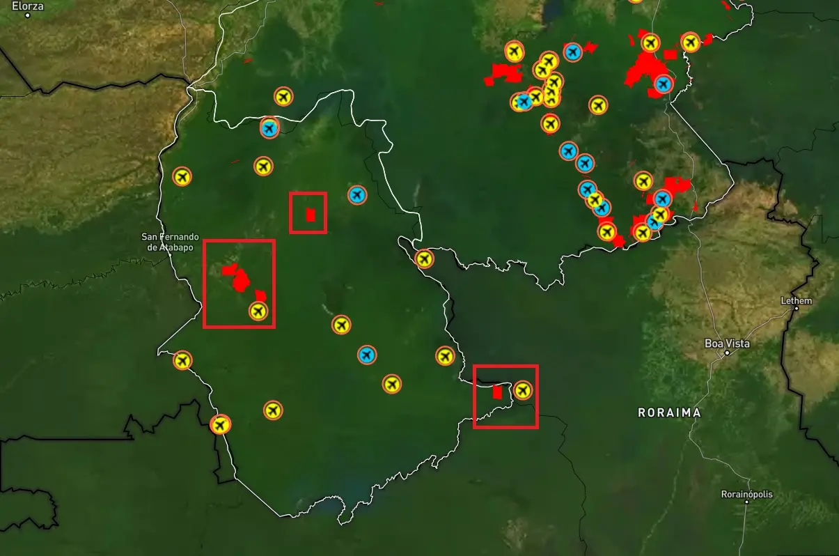
Venezuela's jungle conceals at least 42 airstrips from which planes loaded with gold from the Guayana region secretly take off. Half of these airstrips are located next to one of the many illegal mines that emerge south of the Orinoco River, the longest river in the country and the third longest in South America.
It is also noted that more than a dozen of the airstrips are located on the banks of the Caroní River, which originates near the Brazilian border and crosses Bolívar State from north to south, and is the last major tributary of the Orinoco before it flows into the Atlantic Ocean.
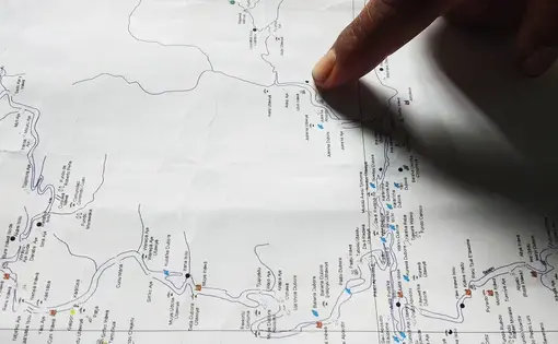
It is not new to warn that a large part of the gold leaves through poaching flights. But a joint work by Armando.info and El País, with the support of the Pulitzer Center's Rainforest Investigations Network and the Norwegian organization Earthrise Media, allows us to show today for the first time on the map of Venezuela the strategic points that smuggling networks have established to take out illicit shipments by air. This is the first installment of the series, Corredor Furtivo.
The findings are the result of a survey of satellite monitoring information, later processed with artificial intelligence, to see and understand the evolution of the mining phenomenon in the Venezuelan Guayana, north of the Amazon.
With the help of experts, an algorithm was programmed to recognize and associate images similar to those corresponding to zenithal shots of open-pit mines and clandestine runways, and thus identify these patterns in the jungle. The result distinguished 3,718 points with illegal gold exploitation in the states of Amazonas and Bolivar, entities that total 418,145 square kilometers of surface, almost half of the Venezuelan territory.

The proximity between runways and clandestine mines can be seen, for example, at the point corresponding to the coordinates 4°45'25.2 "N 61°29'07.2 "W. In that site of the Gran Sabana a runway is observed in the middle of a territory in which the expansion of open-pit mines is evident since 2015, as found in a historical monitoring of the Sentinel-2 satellite of the European Space Agency (ESA, for its acronym in English).
The Gran Sabana, southeast of Bolivar state, near the border with Guyana Esequiba, is a unique landscape and ecosystem, a 10,000-square-kilometer high plateau that serves as an access threshold to the region of the tepuis, characteristic massifs of the Guiana Shield.
Something similar is found at coordinates 5°58'54.2 "N 63°13'41.7 "W, a point within Canaima National Park. Founded 60 years ago and declared a UNESCO World Heritage Site in 1994, Canaima National Park is not only the setting for Angel Falls, the highest waterfall in the world, but the crown jewel of natural monuments in southern Venezuela.
At coordinates 4°52'22.1 "N 62°26'02.1 "W, on the banks of the Caroní, two intersecting runways were recorded in 2015. Today, one of them is still visible very close to a large open pit mine on the other side of the river.
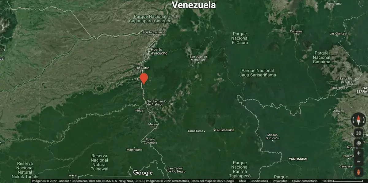
Some of the runways were already in place decades earlier to serve indigenous communities or remote populations scattered in the rugged geography of the area, but it is striking that these facilities are located very close to emerging mines. For example, the case of the Piaroa community (Uwottüja people) established in the northwest of the state of Amazonas, in a territory known as Janacome, in the Atures municipality, on the border with Manapiare. There, next to the indigenous camp, a track stands out at the coordinates 5°37'58.3 "N 66°26'48.7 "W, barely two kilometers from three emerging mines of which not one, not two, but three sources affirm — under condition of anonymity — that they are in the hands of the dissidence of the Revolutionary Armed Forces of Colombia (FARC).
Meeting of Two Worlds
More than a particular denunciation, this is a string of stories that attest to the presence of guerrilla troops in the Venezuelan Amazon, and the use and exploitation of this territory for mining, despite the fact that it is prohibited by law: "Beware of the guerrillas! "is a rumor, an advice, a fear, that has been in the air for at least the last decade, but that has rarely been as evident as when, two years ago, in a sort of meeting of two worlds, the guerrillas introduced themselves to the local indigenous people as their new neighbors.
On that day, February 23, 2020, a commission of fighters from the National Liberation Army (ELN) and the dissidents of the Revolutionary Armed Forces of Colombia (FARC) presented themselves during an assembly before the representatives of the Piaroa communities of the banks of the Autana, Cuao, Sipapo and Guayapo rivers, in the locality of Pendare. There, in that jungle corner of the western Venezuelan Amazon, halfway between the right bank of the Orinoco River and the famous Autana hill — of a singular shape, like a stony tree trunk, protagonist of aboriginal myths and tourist posters — they formalized their new camps and asked to adopt the good neighbor policy.
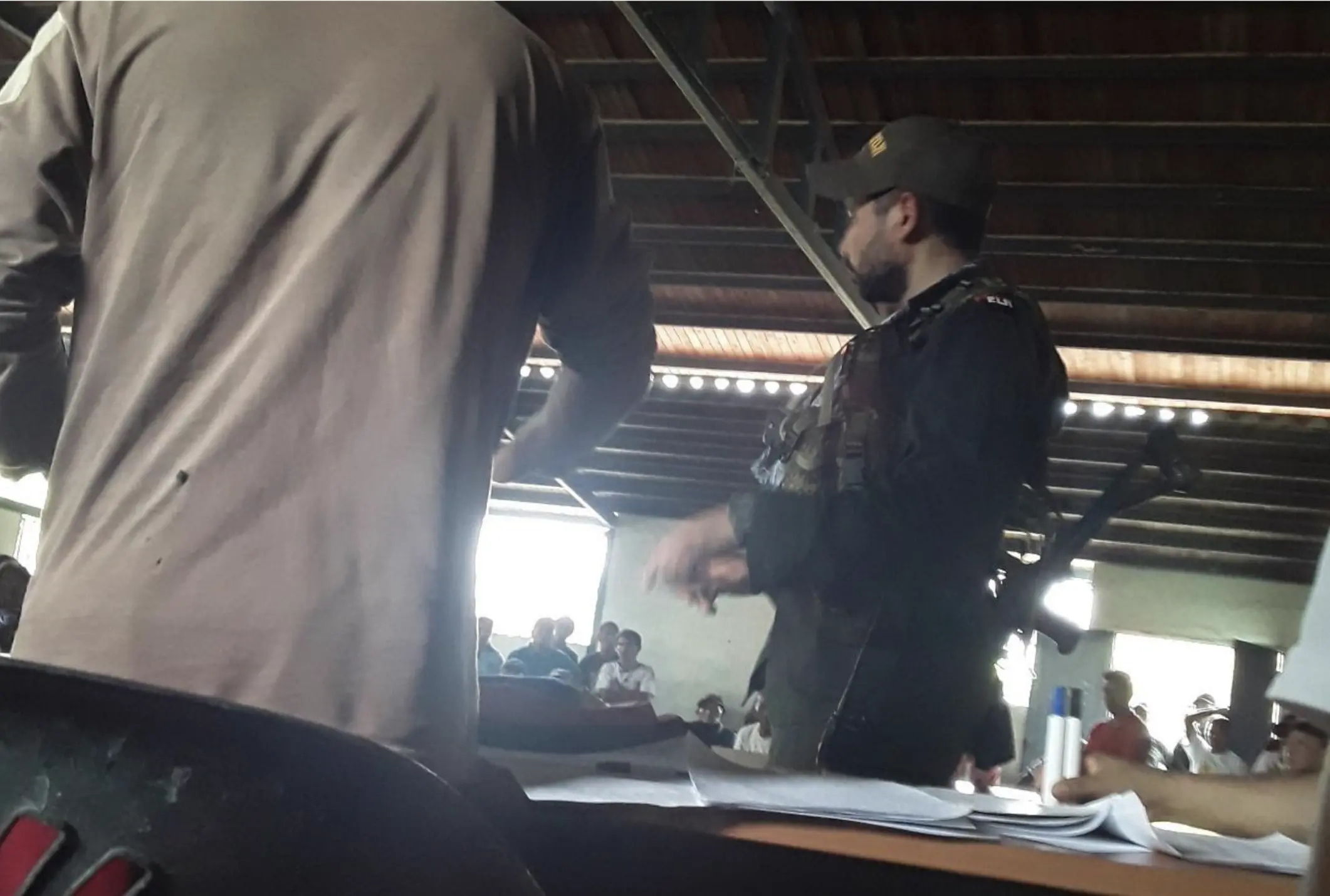
At the meeting, the guerrillas assured that they came in peace, that their intention was to protect the territory, and that they even had the approval of the central government in Caracas. But not only did they meet with indigenous resistance, but they never expected that the Piaroa would also be able to record audio and video, thus leaving a record of the presence of irregular groups. Thus they gathered the testimony of one of the indigenous, who in his intervention during the assembly warned about "a clandestine airstrip that exists there in Autana [one of the municipalities of northern Amazonas and epicenter of the Piaroa territory]." "Is that just a story?" he asked, challenging the uniformed: "Excuse me, is it possible that there is no airstrip there in Autana?" To this the audience responded in chorus with a clear: "Yes there is!"
"What are you working on? Security? National Security? The people want to know what is going on," insisted the spokesman for the Piaroa. In tune with his words, the Indigenous Organization of the Uwottüja People of the Sipapo River (Oipus) broke their silence three days later, to ask the Venezuelan State to do something. They not only asked the administration of Nicolás Maduro to recognize the support the guerrillas were talking about, but also to expel the planes that have invaded their space. "We declare the rejection of mining exploitation, we also reject that you use our territory for the transit of illicit activities," they stated in the February 26, 2020 communiqué. "That you explain or clarify to our indigenous people about the construction of airstrips, which during the nights [sic], take off and land in the Autana River sector."
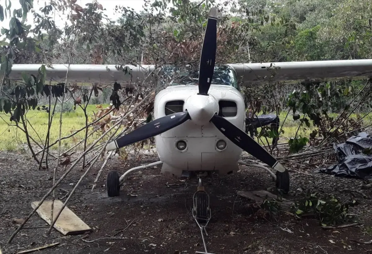
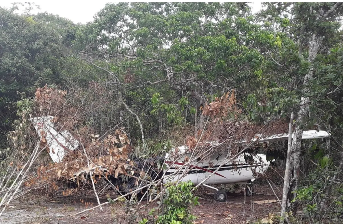
Not a month had passed since that exhortation when another strange warning again showed, in March 2020, that the north of Amazonas has become an air bridge for drug and mineral trafficking: a small plane appeared abandoned near the town of San Pedro del Orinoco, coordinates 04°36′30.52″N 67°46′12.88″W. The wreckage of the aircraft still showed on the tail and fuselage the initials of its initials, "PT," which correspond to the Brazilian air registry.
Something Smells Bad In San Pedro Del Orinoco
The indigenous people locate a track at this point on the border with Colombia. It is, however, a place that went unnoticed in the satellite tracking programmed for this work. Still a year later, in March 2021, Planet, Digital Globe, and Google satellites did not register any track in the area; neither did Sentinel-2, which served as the basis for programming the algorithm of this work. At that point, however, a long dirt road could be seen, along which the indigenous people must have traveled when they found the plane.
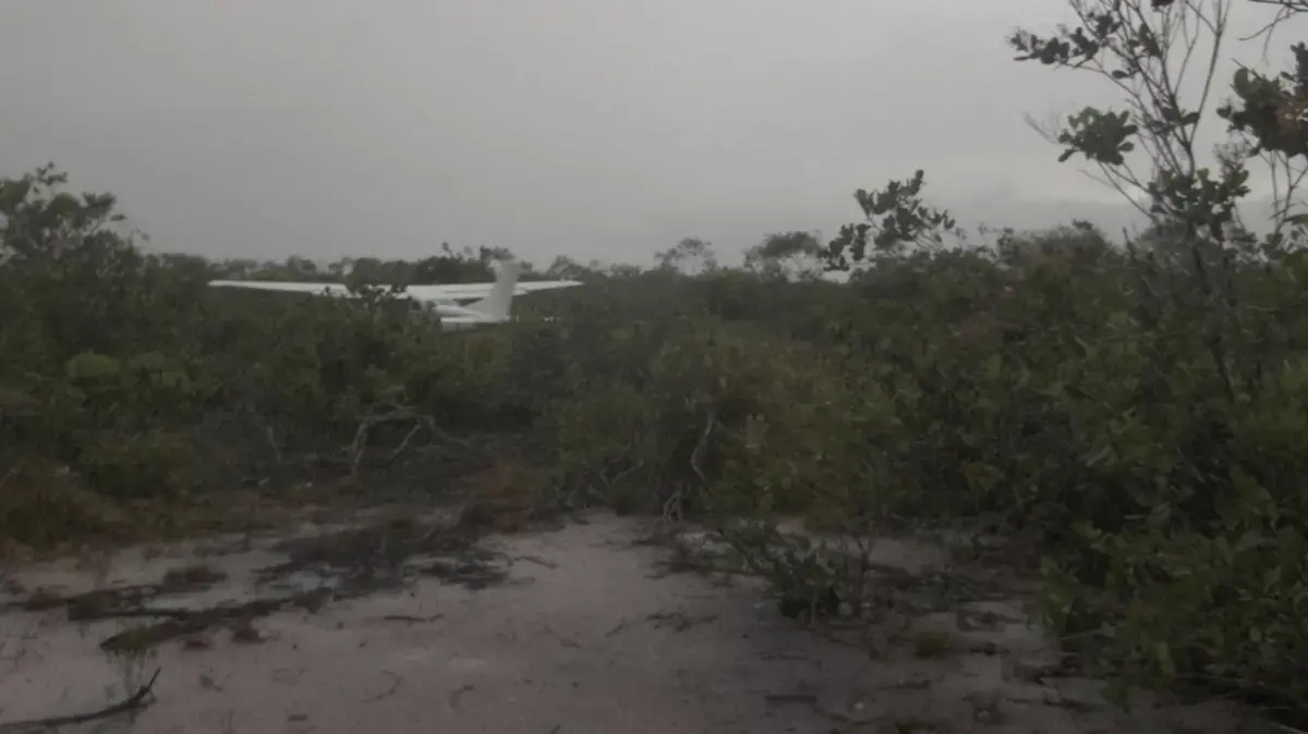


It is evident that something is happening in San Pedro del Orinoco. Although in March the satellites did not manage to spot the runway, in September they detected a new straight line of about 340 meters long at the same point. A kind of improvised runway that would represent a real challenge for any pilot, despite the fact that it is a clear terrain with no mountains or forests to hinder any landing.
Two other clandestine runways had already appeared in the area in 2018. But, against the regular policy of Nicolás Maduro's government, which prefers to ignore the guerrillas growing in Amazonas, the then Minister for Interior Relations, Justice and Peace, General Néstor Reverol, announced that they had destroyed both runways and seized 450 panelas of cocaine in the Cacahual sector, a point on the border with Colombia located 30 kilometers from San Fernando de Atabapo. "In the place of the seizure, two clandestine runways and aviation fuel tanks with 3,200 liters were located," he said on April 30 of that year in his Twitter account.
In 2021, other news circulated about furtive flights of aircraft with Brazilian registration plates that had to make emergency landings in the area. In one case, a twin-engine Piper, model Navajo, with acronym PT-JEH, made a surprise landing on September 23rd at the main airport of Puerto Ayacucho, capital of Amazonas state, on the right bank of the Orinoco river and in the middle of the border with Colombia. The emergency occurred after having exhausted the fuel reserve. It was flying from the city of Boa Vista, in the state of Roraima, northern Brazil, to the municipality of Pedro Camejo in the state of Apure, in the plains of southwestern Venezuela. Although it was not carrying any cargo, according to the military report, during its inspection it showed traces of drugs, and its two crew members — Italian Deverson Ceccaroni and Colombian Duvier Linares — were arrested.
The aircraft, although owned by the Brazilian company AEB Taxi Aéreo y Transportes Ltda, did not have valid air cab operating permits and its airworthiness certificate was suspended, as confirmed by the official registry of Brazil's National Civil Aviation Agency (ANAC). The case is similar to that of the Brazilian PT-KFN plane, which was forced to land on the other side of the Orinoco River - in the Colombian city of Puerto Carreño, capital of the department of Vichada - and in which traces of cocaine hydrochloride were also found. The two Brazilian nationals on board were placed under arrest.
It is one of the few pieces of information, always generated by fortuitous events, that leave evidence of a daily activity. Otherwise, nothing would be known about this transit. The Venezuelan Amazon has become a regular route for Colombian cartel networks; the territory of Venezuela's southernmost state has a low population density, housing just 0.5% of the 32 million Venezuelans in an area of just over 17% of the country. So there are not many witnesses to what goes on there. Extensive, jungle-like, with an abrupt orography and crossed by a tangle of mighty rivers that is both an obstacle and the most practical form of mobility and transportation in the region, this entity lends itself to the concealment of illicit activities.
"Silent Genocide"
Even in the Upper Orinoco, probably the most remote and impregnable region of the country, only fully explored in 1951 by a Franco-Venezuelan expedition, there are traces of both mines and clandestine airfields. The local Ye'kwana and Sanemá peoples - grouped in the indigenous organizations Kuyunu and Kuyujani - filed a complaint in July 2021 with the Amazonas State Attorney General's Office about an invasion of at least 400 Brazilian miners — the so-called garimpeiros — equipped with 30 hydraulic pumps that, according to their words, were generating "mercury contamination in the waters," "disease contagion," and even a "silent cultural genocide." This complaint was ignored, like so many others filed at least since 2013 by aboriginal communities of the Amazonas state not only before the Public Prosecutor's Office, but also before military agencies, national and local governments, as well as parliamentarians.
"Ye'kwana and Sanemá leaders point out that they are being victims of selective murders perpetrated by these garimpeiros, when they feel they can go against them." This they alerted the Public Prosecutor's Office in a document dated and sealed on July 21, 2021. "The garimpeiros are heavily armed and enslave men, women, and children of the Sanemá people. They also have a clandestine track of about seven kilometers (7 km) in length."
The same indigenous organizations added a week later, by means of a public communiqué, that in that remote site in southern Amazonas — which is easier to reach from Brazil than from Venezuela itself — there were two helicopters that took food and materials to a mine located in the Wasiri channel: "Every three days planes go to look for gold, taking between 40, 50 and 100 kg a day."
Upset, frustrated, dissatisfied, in the document the representatives of the indigenous peoples go on to speak of two clandestine airstrips: the first, "in the middle of the jungle", where a "small plane that always heads towards the area of Brazil" arrives, and the second, located seven kilometers from the garimpeiros' mine, in the Simada Woichö sector, at coordinates 03°49′9. 51″N 64°35′59.818″W, whose location coincides with one of the runways detected by the algorithm developed for this work.
In any case, the piece of land mentioned in the denunciations represents only a footnote in the list of clandestine mines that sprout and flourish in the south of the country. In the state of Amazonas alone, this satellite tracking detected 303 mining sites, despite the fact that the activity is expressly forbidden in this, the country's most important forest reserve. Among these points are a mine that appeared months ago on the southern border, just ten kilometers from the Brazilian border, as well as another in the Yapacana hill, one of Venezuela's ecological jewels and a Natural Park. This area, where in 2009 the government of Hugo Chavez carried out a large military operation to expel hundreds of illegal miners to Colombia, has been deforested for at least five years.
The non-governmental organization SOS Orinoco, which has studied mining depredation in recent times, closely follows the situation in the national parks. In the case of Yapacana, it highlights that from 2019 to 2020 alone it lost new forest areas, with deforestation "from 2,035 to 2,227 hectares", while mining sites increased "from 36 to 69".
40,000 Soccer Fields
The proportion of forest affected and the speed of deforestation in Venezuela surpasses any precedent in the Amazon region. In 2020, the Amazonian Network of Geo-referenced Socio-environmental Information (Raisg) totaled 4,472 points with illegal mines throughout the Amazon. Although half of these mines were in Brazilian territory, 32% were in Venezuela, although its forests represent only 5.6% of the total Amazon. The organization Provita reports more than 380,000 hectares of forest lost since 2000. Most of the deforestation corresponds to forested land converted into conucos and land destined for the agricultural sector, but mining areas — and the degradation they cause in rivers and local communities — have tripled in a matter of 20 years: "Although the area destined for this use is low (0.1% of the total area), in the period 2000-2020 there is a sustained increase from 18,490 hectares in 2000 to 55,090 hectares in 2020, with an estimated annual growth rate of 5.5%."
This trend is repeated in other specific areas. Neither the pandemic nor the quarantines have slowed the pace of the mines. The algorithm of this work found 3,415 mined points in Bolivar State, the largest in Venezuela. As already mentioned, there is a clear line along the Caroní River and other waterways in its basin, the emerging mines of Canaima, or the traditional deposits of Las Claritas, where there have been legal concessions. But the consequences of illegal mining can be seen in the surroundings of the urban centers of Guayana, and even in the dams of hydroelectric power plants such as Guri, Macagua, Caruachi, and Tocoma, all upstream on the Caroní.
Artisanal gold mining involves massive logging and pumping pressurized water until the land is bare. Toxic wastewater is left in distinctive yellow, tan, and turquoise ponds, surrounded by clumps of deforested land.
The computer learns to identify some of these features in the satellite images, along with other patterns that humans do not recognize with the naked eye. This reveals a clear map of deforestation in Guyana. It also helps to guide the first journalistic work on the mines in that region, this Corredor Furtivo series, which approaches the subject from a general vision in order to transcend the anecdotal and the chronicles that present reports from specific points.
Whichever way you look at it, the scale of mining in southern Venezuela is enormous. From the perspective of the space observation satellites, whose high-resolution images were used for this journalistic project, deforestation covers the equivalent of 40,000 soccer fields. The algorithm designed for the project manages to analyze the images by sectioning them into blocks of 28 x 28 pixels. At ground level, each of these 28 x 28 pixel patches represents an area of 78,400 square meters (280 x 280 m), or about 11 soccer fields in the middle of the actual jungle. Along with the scars of mining, the images taken from space now show 42 clandestine airstrips that, in addition to destroying the natural habitat, violate national sovereignty and connect this region with cross-border criminal activities.
These are the dilemmas of Venezuela today and in the future. Even with some political negotiation; even if Nicolás Maduro remains in power or any other leader, from Chavismo or the opposition, crosses the threshold of the Miraflores Palace to succeed him, these are the problems not only of the so-called Bolivarian Republic, but of the entire region.
(*) This is the first installment of a series researched and published simultaneously by Armando.info and El País, with the support of the Pulitzer Center's Rainforest Investigations Network and the Norwegian organization EarthRise Media.
Edward Boyda, Caleb Kruse, Jorge Luis Cortés, Cristian Hernández, Javier Lafuente, Ewald Scharfenberg, Guiomar del Ser, Fernando Hernández, Ana Fernández, Eliezer Budasoff, Alejandro Gallardo, Luis Sevillano, Ignacio Catalán, Vanessa Pan, and Pablo Rodríguez participated in the design, programming, and assembly of the algorithm, map, research and editing.