Story
 May 14, 2024
'How Do You Stop the Ocean?' Climate Change at Norfolk's Doorsteps
Country:

W&M students developed reporting and writing skills with the support of Pulitzer Center staff.


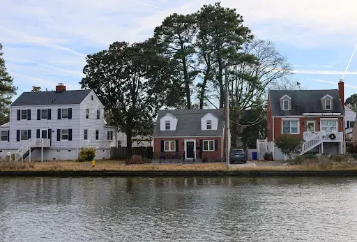
Christina Laughlin and her partner, John Copeland, moved into their new-build waterfront home seven years ago when they began working at the nearby naval base. Their home towers above the others on their street. It takes nine steps to reach the front porch, and their two-car garage—a rare sight on the block—is raised 13 feet above the street.
Right over the threshold, the wall is lined with brightly-hued rain gear and tall boots for the family of four.
Laughlin and Copeland thought they were prepared for the dangers that poor weather could bring to the waterfront.
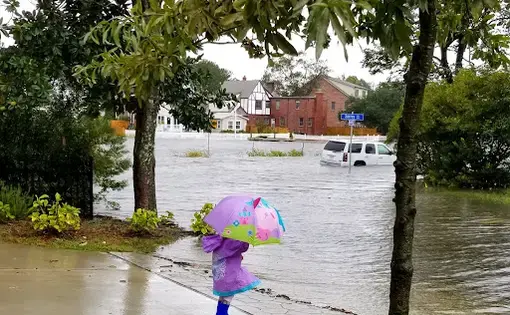
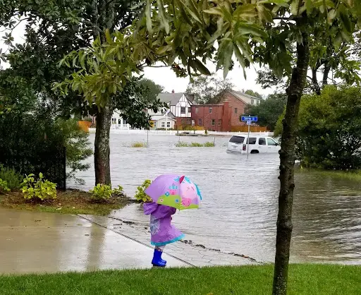
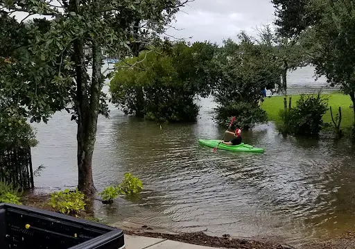
But on a cloudless day after Hurricane Dorian in 2019, Laughlin saw the water rise about 4.5 feet from the front window of her home in Larchmont-Edgewater, an idyllic neighborhood in Norfolk, Virginia. As she worked remotely from her front porch, she witnessed people kayaking the streets and watched over her 3-year-old daughter as she waded past her driveway.
In Norfolk, life requires you to live with the water, even on sunny days. The sea levels are rising in Norfolk faster than anywhere else on the East Coast, and the land is sinking twice as fast.
“In the future, fish will live here,” Copeland said, gesturing widely to the area around his home.
Copeland and Laughlin’s family are among more than 13 million Americans estimated to face displacement by 2100 due to sea level rise. But, a patchy system of federal, state, and local planning dances around the risks of life in a flood zone.
Laughlin and her family acknowledge that life in Norfolk requires a shift in mindset. “Real estate is supposed to be a long-term investment that you pass on to your kids,” she said.
But her neighborhood’s best attributes—the schools, walkability, proximity to nature, and of course, the waterfront—are under constant threat from rising sea levels.
“You deal with it until you can't anymore,” Laughlin said.
Life in an Endangered City
The surrounding Tidewater region is home to 1.7 million Virginians who live on the edge of a crater rim formed 35 million years ago: when a mile-wide meteor slammed into the Chesapeake Bay.
The land under these residents is sinking, in part, due to groundwater consumption and the slow lowering of land in the wake of glacial retreat. As the land subsides, the weakening Gulf Stream contributes to rising seas along the coast. The combination of geographic and oceanic forces places Norfolk, a city carved out of the water, at losing odds with the sea.
Today, Larchmont-Edgewater’s residents treasure its mixed colonial revival, Craftsman, Victorian, and contemporarily-styled properties; waterfront views; and the abundance of parks punctuated by lush magnolias and crepe myrtles in the warmer seasons. They include the families of active-duty service members at nearby Naval Station Norfolk—like Laughlin and Copeland’s—as well as defense contractors, veterans, faculty at Old Dominion University, and retirees.
But over 100 years, the water that bolsters the city’s ports and military infrastructure—its economic lifeblood—has risen approximately 19 inches and, on high tides or rainy days, submerges roads, creeps into yards, and often, finds its way into homes. Year after year, ecologists and climate scientists place Norfolk on lists of cities endangered by climate change.
Yet the consequences of being on these lists aren’t top of mind for many Norfolk residents. Kim Sudderth, vice chair of the Norfolk Planning Commission, says that many residents do not connect the idea of climate change to immediate consequences, like avoiding downtown when it rains, changing what times they leave and return home, or losing multiple vehicles to floods (Sudderth has lost three).
“I would ask people, like, ‘When you think about environmentalism, what is the image that stands out?’” Sudderth said. “People are like, ‘Oh, yeah. Polar bears.’”
Even consequences like losing car insurance after repetitive losses and home insurance companies pulling out of the region seem disconnected.
Then there’s the issue of trust. Sudderth lives in Berkley, a historically Black neighborhood in Norfolk’s southside. Last year, the city approved a $2.6 billion project developed by the Army Corps of Engineers to construct floodwalls along the waterfront to address flooding from storm surges to protect federal installations.
However, the Army Corps’ initial cost-benefit analysis of property values excluded predominantly Black and historically redlined neighborhoods from the seawall in favor of native vegetation buffers. Norfolk later requested additional barriers from the Army Corps for these communities, but their funding and construction are not guaranteed pending another potential years-long study.
Actions like these make it hard for residents to trust government-led interventions. Sudderth said that residents have told her that, “This is something that white people are concerned about. This isn't something that concerns Black or brown people or poor people, you know?”
Sudderth believes that making environmentalism more accessible includes developing an understanding among residents of how recurrent flooding will affect their homes at the individual and household levels. She started as an organizer with Mothers Out Front in 2016, when she helped communities address the direct impacts of recurrent flooding.
In Tidewater Gardens, just across the Elizabeth River from Berkley and Campostella Heights—another historically Black neighborhood—flooding contributed to student absences from nearby Tidewater Park Elementary. The water would get “thigh-deep” on young students, and without access to a bus, local parents worried about their children losing instructional time. Local organizing resulted in student transportation when the streets flooded.
At the local level, Sudderth said, “No one wants to talk about it.” To residents, it’s scary to think about losing a home. To city officials, it’s expensive and politically volatile. No one wants to be the one to say “these blocks right here—there's nothing we can do. You better start talking about moving.”
A Lack of Courage
Among state officials, the reluctance to even verbally acknowledge sea level rise, let alone climate change, took years to overcome, according to Jay Ford, the Virginia policy manager at the Chesapeake Bay Foundation.
Ford points to the creation of the Coastal Resilience Master Plan (CRMP)—a framework to assess the impact of Coastal Virginia—as the first time the Commonwealth acknowledged the necessity of a comprehensive regional flood plan.
But, the CRMP, too, makes scant mention of managed retreat as a policy option, writing only that “the Studies, Research, and Best Practices Subcommittee recommend the need for a collaborative effort between state agencies regarding retreat strategies.”
From serving on legislative committees leading to the CRMP, Ford notes “reluctance” to discuss climate migration and the “lack of political courage” needed to plan for it. “The second you do that, you know, you're kind of putting some people on notice that they're going to be a climate refugee.”
To environmental policy advocates, managed retreat, or the proactive movement of people, infrastructure, and coastal ecosystems away from land loss and areas at high risk for repetitive natural disasters, represents one of the final frontiers in climate planning that governments are reluctant to claim responsibility for.
“You ask 20 resilience professionals, ‘Is migration part of the solution?’ and you will get 100% yes from all of them,” Ford said. “You ask them to write down where they think it should happen, and they will run screaming from the room.”
Local-level “resilience” planning exemplifies how climate change policy is functionally a jurisdictional hot potato that gets tossed around by local governments, states, and the federal government. There is no one-size-fits-all plan to address coastal flooding; changes in Norfolk vary parcel to parcel, block by block.

Norfolk’s Vision 2100 plan to address sea level rise says as much: On a map, four color-coded zones categorize the feasibility of mitigation strategies, like sea walls and living shorelines, by an area’s vulnerability and current and future assets.
In the entire plan, “retreat” is mentioned only once.
“If it’s difficult for state leaders to talk about, it’s impossible for a local council person to talk about, because then you’re talking about people’s neighborhood and houses,” Ford said.
Ford identifies guidance for managed retreat as a state-level responsibility and one area where the state’s resilience planning has fallen short: “If you're not willing to have an honest community conversation around what buyouts and migration should look like in the future, then you're left with, ‘We should put a wall around everything.’ And that's very clearly not the right answer.”
However, funding for the CRMP, even without plans for migration and buyouts, remains at the whims of political will. Last June, Gov. Glenn Youngkin directed the State Air Pollution Control Board to withdraw the state from the Regional Greenhouse Gas Initiative (RGGI), a market-based cap-and-invest program spanning multiple mid-Atlantic and Northeastern states, effective January 2024. RGGI was the state’s sole source of funding for the CRMP.
States participating in RGGI (pronounced “Reggie”) auction off carbon dioxide allowances to the energy sector proportional to their share of the regional emissions cap. In joining the program, Virginia agreed to set aside 45% of its proceeds from its allowance auctions to the CRMP, which amounted to $320 million for the CRMP over three years of participation in RGGI.
“The RGGI departure has really thrown Virginia's promising work in the climate adaptation space into complete disarray,” Ford said.
At the federal level, homeowners seeking recourse for recurrent flooding encounter a public policy that is almost entirely based on limiting damage from one-off natural disasters. States can apply for funding through the Federal Emergency Management Agency’s Hazard Mitigation Assistance grant program, which represents an umbrella of programs that expense a significant share of the cost of property acquisitions and demolitions, elevations, reconstruction, and floodproofing in the hopes of decreasing federal flood insurance payouts.
However, between 2000 and 2023, Norfolk’s approved FEMA applications overwhelmingly prioritized home elevations.
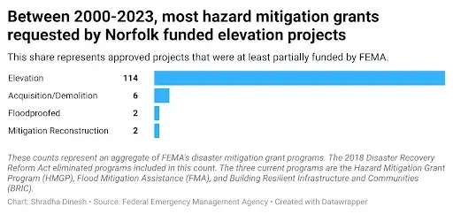
Between fiscal year 2018 and 2021, FEMA approved one mitigation reconstruction project and 15 home elevations. The city’s FY 2022 and 2023 applications are still pending as of April 2024.
A Rising Tide
Gabriella Beale, a realtor in Larchmont, started talking about the influence of flooding in real estate about five years ago after she noticed a listing she was managing took a year to sell because the home’s elevation certificate—a document FEMA developed to determine a specific property’s flood risk—placed it in a higher-risk region. Elevation certificates are based on a property’s flood zone, location and building characteristics, including the lowest floor elevation.
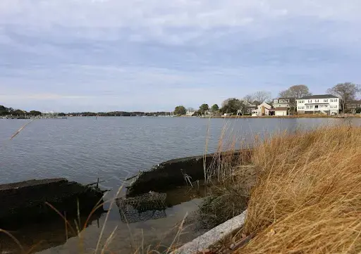
She took me on a tour of Richmond Crescent, a street along the Lafayette River lined by homes and punctuated by docks in the water. It hadn’t rained recently, yet brackish water puddled atop the alligator-cracked asphalt behind a barrier of native grasses and a deteriorating retaining wall.
“Norfolk is thinking, ‘If you look at the flood maps, they’ve gotten worse over time,’” Beale said. “And the interesting thing is that people are still looking to buy in these neighborhoods.”
Most buyers, Beale says, are concerned about the money and the waterfront’s draw, not the “We’re going to flood and lose a house.”
Beale said she once encouraged one of her clients to visit Richmond Crescent to “make sure that they understand what they're getting into so they don't walk away mid-contract.”
Beale stops as we begin to turn around the bend. “I was like, ‘Oh, check out this street,’ and they could not drive down this street, it was blocked [by water].”
A storm didn’t usher in those high waters, but tidal, or nuisance, flooding on a sunny day.
The National Oceanic and Atmospheric Administration forecasts Norfolk to experience 85 to 125 days of sunny-day flooding each year by 2050.
Larchmont-Edgewater is not the only Norfolk neighborhood where the water will come and stay. It is one of several neighborhoods in the “yellow zone” of the city’s Vision 2100 plan. Residents in the yellow zone live where large infrastructure projects would be too expensive to execute. They must learn to cope with the water through a mixed bag of adaptation and retreat solutions.
These essential details remain turbid as homeowners, planners, and politicians struggle to picture Norfolk’s future.
“In 30 years, there’s no way my daughter could live here,” Copeland said. “How do you stop the ocean?” he said. “We’ll stop the wind next week.”