Story
 June 11, 2025
The Unseen Flooding Risk in South Florida: Rising Water Beneath Our Feet
Country:

Project
Floods of Trouble
There is a culture of secrecy behind property-level flooding information in Florida, the state with...

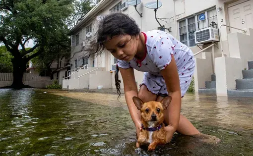
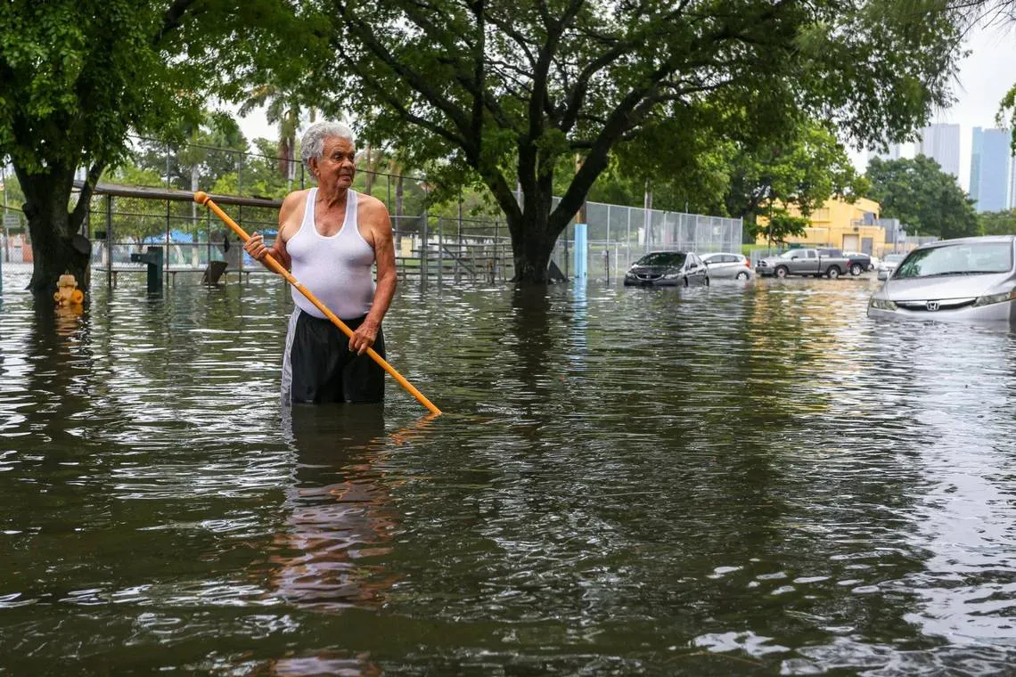
Maybe you rent on a Little Havana street where thunderstorms seem to flood apartments every other summer. Maybe you live along a Fort Lauderdale canal where the Intracoastal seems to lap higher up seawalls with annual king tides. Maybe you’re fortunate to be perched on a limestone ridge in Coral Gables, where street ponding seems only an occasional annoyance.
Wherever you live in South Florida, the flooding you see right now is likely to get worse in the years ahead – despite billions of dollars in drainage projects intended to protect communities.
Climate change carries much of the blame in the form of rising seas and wetter storms, but there also are significant holes in how the region is projecting and preparing for flooding.

As a nonprofit journalism organization, we depend on your support to fund our nationwide Connected Coastlines climate reporting. Donate any amount today to become a Pulitzer Center Champion and receive exclusive benefits!
To put it simply, flood control in most of South Florida has long been engineered to handle one thing: Rainfall, and only a certain amount of it. But rain is only one of the forces already inundating streets and neighborhoods.
Some coastal communities now plan for higher tides from sea rise, most notably Miami Beach, which is pouring a billion dollars-plus into flood protection after years of seeing some streets awash. But few account for the third hidden threat: an underground water table that can rise dramatically from a single storm, quickly saturating the limestone sponge just beneath our feet that helps keep communities dry.
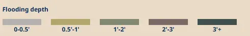
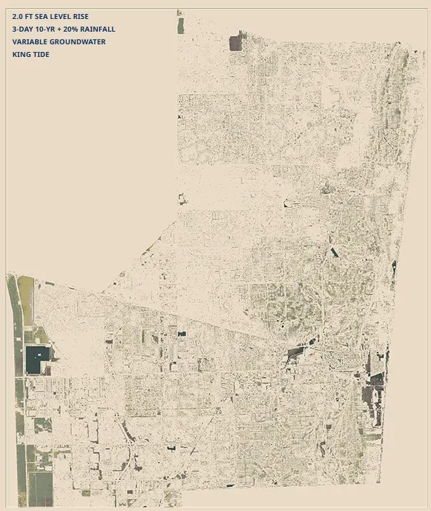
Now, Broward County has just completed a ground-breaking study combining what hydrologists and engineers call “compound flooding” — the triple whammy of rain, rising tides and swelling groundwater levels.
The findings should be eye-opening for the entire region, with maps showing faster and more frequent flooding in many places, particularly in neighborhoods where stalled cars and sandbags already make routine appearances in the rainy season. In the near term, the modeling shows, those street puddles get deeper. Low-lying homes are more likely to see damage. Even relatively small amounts of rain could have big impacts.
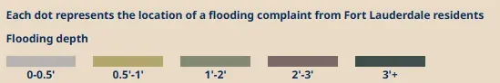
Complaints meet computer models
To assess Broward County’s computer projections of potential future flooding, The Herald overlaid actual flooding complaints Fort Lauderdale recorded from residents between April and May 2023 after an infamous ‘rain bomb’ storm. The two maps closely align. Broward’s analysis shows such extreme scenarios could become more common countywide under the triple whammy of flooding from heavier rains, rising tides and rising groundwater levels.

“We don’t have the luxury of just having sea level rise,” said Jennifer Jurado, chief resilience officer for Broward County. “It’s sea level rise plus it’s raining, it’s sea level rise plus storm surge.”
And Broward’s study isn’t even a complete picture of the challenges. Sea rise alone is already slowly strangling South Florida’s 80-year-old primary drainage system — a vast network of canals that flow to the coast, pushed by gravity and increasingly necessary massive pumps.
At least one drainage canal in South Florida already does not work under current high tides — the pressure of the sea is essentially bottling the water up inland. And many more are set to fail, soon. More than 15 drainage basins in Miami-Dade alone are expected to be essentially nonfunctional with as little as two feet of sea rise. Scientists say we could see that much by 2060 or so.
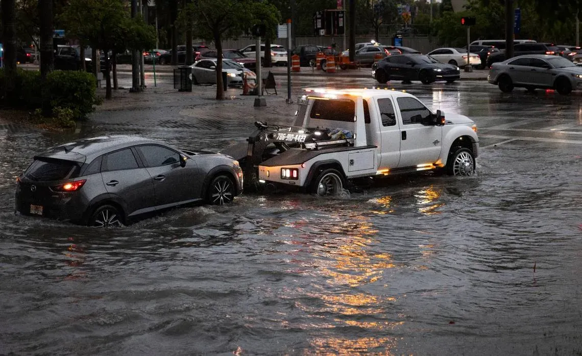
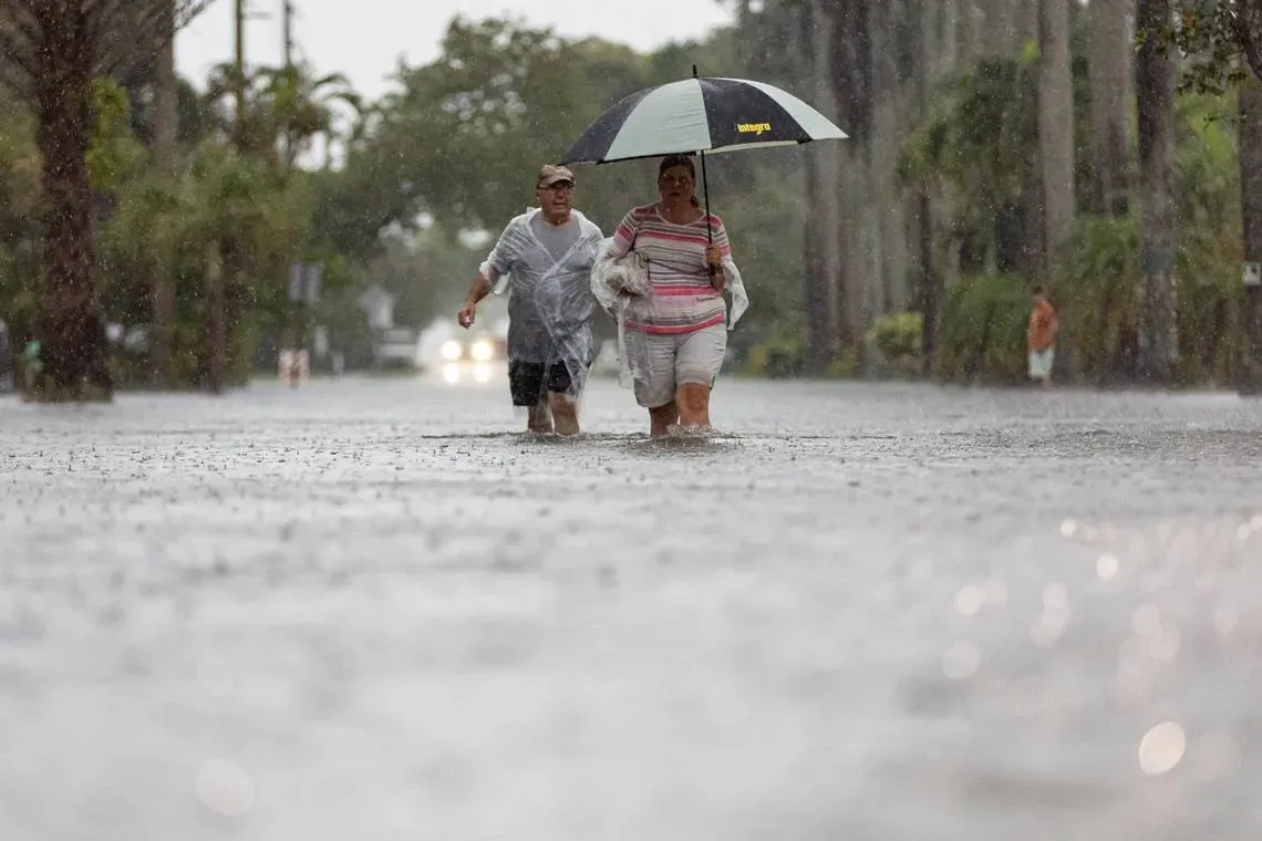
But while two feet may feel far off, experts say the impacts of rising tides and extreme rainfall are being felt now. The widespread street flooding from two gloomy days of rain last week in South Florida is just a hint of things to come. Storms, scientists say, will only continue to get more intense.
“One inch makes a big difference in Florida,” said Carolina Maran, chief resilience officer for the South Florida Water Management District, which oversees flood control and drainage canals for 16 counties. “In some structures, six inches of sea rise already means like 80%, 90% reduction, meaning we don’t have the power to force the water out anymore.”
The district has drawn up assorted plans to address the problem over the years, most focused on installing more powerful pumps to push against the tide and dredging canals even deeper so they can hold more water. One thing is clear: Residents will face an increasingly high price to stay dry. The latest district report pegs the total at around $2 billion to renovate the worst-off South Florida areas alone.
The federal government has also launched a massive study that could provide a blueprint for additional projects that will cost even more — and potentially even pay for some of them. But even understanding what needs to be done has proven to be a massive and complicated challenge, stalling any quick fixes.
Although the re-study of the geriatric system kicked off in 2022, planners now say the earliest they’d be able to start projects would be 2030. And that’s only if Congress agrees to pony up yet more billions needed to protect South Florida homes and businesses.
In the meantime, cities and counties are making plans — most with only a partial understanding of the multiple flood threats they face.
“Compared to other countries, other places in the country, we have lot more complexity that we have to build into the models,” said Jayantha Obeysekara, head of Florida International University’s sea level solution center, who previously led computer modeling for the water management district.
“For us, inches matter.”
The hidden flood factor The long overlooked and least understood threat in South Florida is the water we don’t see — the massive natural drinking water reservoir right under our back yards called the Biscayne Aquifer.
On good — dry — days, groundwater can be as much as 10 feet below the surface in South Florida. When it rains hard, that space disappears, sometimes quickly.
During the last several intense flooding events in Florida, monitoring wells operated by the U.S. Geological Survey found water levels jumped as much as five feet in a single day in some flood-prone spots.
Scientists have found that sea level and groundwater levels are connected in South Florida. When tides rise, so too does that water underneath our streets and buildings – an effect that can extend far inland. This underground pool is why builders can’t simply ring off South Florida with sea walls to buffer sea rise.
Already, those higher groundwater levels have been linked with more intense floods, like those that have swamped homes and streets in Fort Lauderdale, Aventura or Hialeah in the last few years. They’re likely to become more common.
The effect, hydrologists say, will be profound. With three feet of sea rise pushing up groundwater, some low-lying inland spots in Miami-Dade County could turn into ponds during high tides — even on sunny days. Even now, a casual summer afternoon rainstorm in vulnerable parts of Miami can be enough to flood parks and roads. In decades, that same storm may reach homes. And severe rain, like hurricanes bring, could produce even more devastating consequences.
And a threat that once seemed far off is picking up pace. It took 80 years for Miami to see a foot of sea level rise, with 8 of those inches in the last 30 years. The next foot is expected in a mere 30 years. The next foot could only take 20. The next, just 10.
Typically, big multi-billion-dollar infrastructure projects are supposed to be designed to work for 50, even 100 years. But nobody in South Florida is designing drainage systems for what many experts predict will be happening that far out. Right now, building codes and local plans for drainage improvement only account for flooding from rain or big hurricanes, although some communities have started to account for sea level rise, too. Federal and state agencies, the Herald found, do not regularly consider groundwater in flood planning. They say it’s costly and complicated.
Tom Frazer, head of the Florida Flood Hub at the University of South Florida, said the issue of compound flooding is “top of mind” for his group, which was charged by the state with researching how climate change affects flooding.
Scientists seem to be getting a handle on each of the individual flood factors, he said, but so far, few appear to have figured out how to mesh the various computer models.
“It’s not as integrated as it probably needs to be,” he said. “We recognize all the component parts, and it’s hard to put all of those together. That’s the contemporary challenge … and we’re all trying to get there.”
New maps, higher risk
Broward, with its new study, has arguably produced the most in-depth look at future flooding risks. Working with consultants over the last few years, the county analyzed dozens of different scenarios of extreme rainfall and hurricane events, adding in the compound flooding impacts of higher tides and high groundwater levels.
The results suggest we’ve been underestimating rising risks.
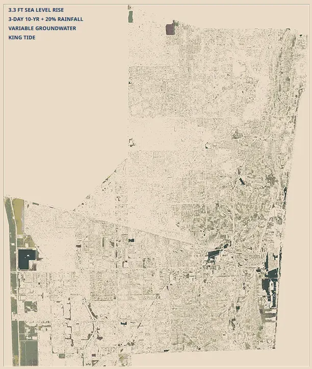
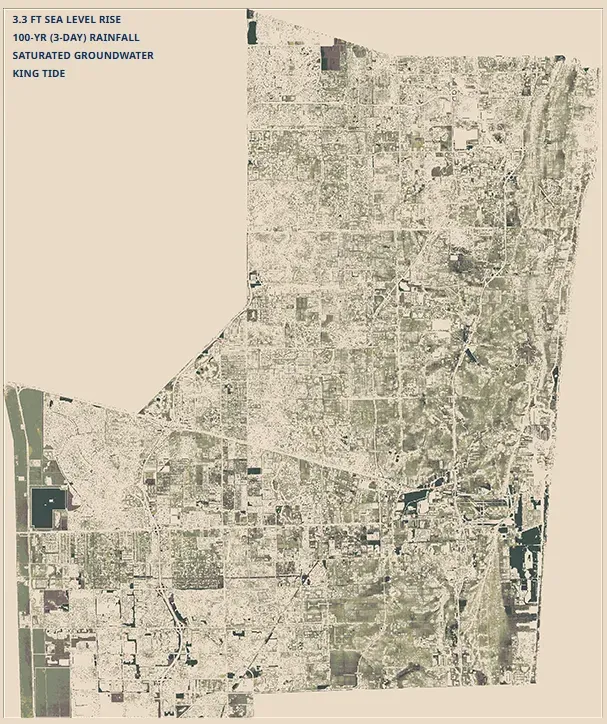
Broward flooding scenarios
The county modeled how much flooding it would see under different levels of rain, sea level rise, groundwater levels and storm surge in the coming decades if it didn't make any infrastructure changes to address the deluge. These maps help Broward plan and prioritize flood fixes.
In April 2023, the city of Fort Lauderdale got a glimpse of the worst-case future when it was rocked with a record-breaking amount of rain: 25 inches in 5 hours. Flooding devastated low-lying neighborhoods, like Edgewood, and stranded hundreds of drivers, flooding out cars in downtown streets turned into rivers and shutting down runways at Fort Lauderdale-Hollywood International Airport.
Fort Lauderdale streets are built to handle about 3 inches of rain in a day in its older neighborhoods and up to 7 inches a day in newer areas. So the system can be quickly overwhelmed by strong storms, even those less wet than the infamous “rain bomb.”
Developers and state agencies scoff at the idea of building drainage systems designed to handle a freak storm like that, calling it an unnecessary and extreme expense. But the combination of climate change and compound flooding calculations makes it increasingly clear that current designs won’t cut it either.
“The challenge is that you can’t plan all infrastructure under this combination of the most severe of scenarios, but you do want to understand what those scenarios look like,” Jurado said.
Broward’s analysis found that far less rain could produce a similar disaster in the decades ahead.
With 3.3 feet of sea rise (expected by around 2070), a king tide and high groundwater levels, just 18 or so inches of rain could do it. Under that scenario, certain spots of Fort Lauderdale, like the airport, would once again be under five feet of water.
“The reality is that under the right conditions, those are realistic flood scenarios,” said Jurado.
Side-by-side, Broward’s maps show that without taking groundwater into account, planners are only seeing part of the picture. The study didn’t reveal vast new places to worry about but they underline that the timeline is shorter and the potential impacts more severe for the most flood-prone areas.
“We all know that under the right conditions, any of our communities could flood,” Jurado said. “The question is: at what level?”
Credits
Alex Harris | Environmental Reporter
Susan Merriam | Data Journalist
Sohail Al-Jamea | 3-D Animator
Neil Nakahodo | Illustrator
Matias J. Ocner | Photography
Alie Skowronski | Photography
Sam Navarro | Photography
Pedro Portal | Videography
Curtis Morgan | Editor
Carolina Zamora | Audience Engagement
How we reported this series
For this story in the Floods of Trouble series, The Miami Herald reviewed flood vulnerability studies and stormwater master plans for multiple municipalities, including the South Florida Water Management District, and talked to experts at the city, county and state level on compound flooding.
For this series, the Miami Herald also commissioned a study from the University of Miami Rosenstiel School of Marine, Earth and Atmospheric Science to analyze which spots in Florida would be most affected by climate change-induced flooding in the coming decades, an analysis that revealed the limitations of basing future plans primarily on tidal flooding.
Sources
Resilient Environment Department, Broward County; Broward County Document the Floods; Fort Lauderdale Hazard Reports; Broward County Cities; U.S. Census Bureau; Google Maps; OpenStreetMap