Project
Paths to Resilience
Sea level rise and other effects of climate change are changing life for residents in coastal North...


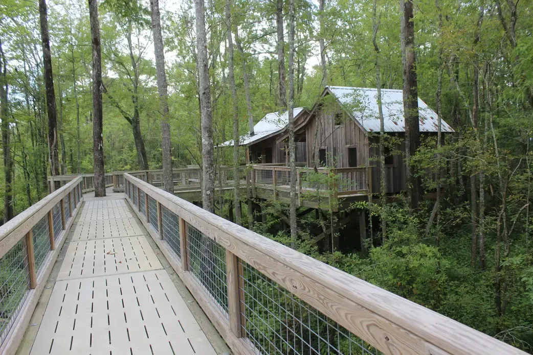
The treehouses were an early sign that Windsor, Bertie’s county seat, was onto something. When there’s a river running right through your town, resilience requires finding creative ways to coexist with the river.
“It’s a source of flooding, but it’s also a source of recreation,” County Commissioner Ron Wesson said of the Cashie River.
So, five years ago, the town took the boring concept of flood adaptation and made it fun — and a revenue-producing tourist attraction. Accessible via an elevated boardwalk, two treehouses were built among the cypress canopy along the river, each with a sleeping loft and basic furnishings, with a shared bathroom facility available nearby.
Now there’s a “village” of three of the rugged cabins, elevated safely — and irresistibly — above the water. They’re so popular, with weekend bookings filled straight through the summer, that the town is proposing to add two more.
“Two of them have trees coming through the middle of them,” Wesson said in a recent interview.
Canoes and platforms are also available to rent for “glampers,” or those who enjoy glamorous camping, rounding out offerings for the region’s nascent ecotourism industry.
Positioned in the center of the Albemarle-Pamlico estuarine system, Bertie County — specifically, Windsor — in the last two decades has suffered some of the worst repeated flooding disasters in inland northeastern North Carolina, an area increasingly beset by changing climate impacts such as flooding from rising sea levels and intense rains.
In 1999, downtown Windsor was inundated with more than 6 feet of floodwater during Hurricane Floyd, destroying dozens of homes, businesses and public buildings. It flooded dramatically again in 2016 during Hurricane Julia. Then, just three weeks later, Hurricane Matthew drove 7 feet of water into the town, destroying nearly 40 homes and numerous businesses.
The one-two punch in 2016 shook Bertie officials into realizing expert help was needed to forestall a future of constant flooding.
But after numerous scientists and engineers evaluated drainage and flooding dynamics in the Cashie River Basin, there were no easy answers.
“We have three major rivers that come together,” Wesson said. “When those rivers back up, it dumps that water into our communities, Windsor especially.”
Potential remedies, such as diverting water to retention ponds or spillways, he said, would help, although it would most likely only reduce the worst flooding instead of preventing it entirely. And although more buildings are being elevated on pilings, even that tactic is not failsafe or always possible.
Considering the billions in mitigation costs the town faces — or accept the loss of the community — town leaders are now making long-term plans to gradually relocate to higher ground.
“There is no real major solution,” Wesson conceded.
On March 17, Windsor was one of 25 communities to be awarded a total of $675,000 in funding through the North Carolina Department of Environmental Quality Division of Coastal Management’s new Resilient Coastal Communities Program. The grant funds will go toward assessing the community risk and planning, selecting and prioritizing projects, as well as engagement of citizens in the process.
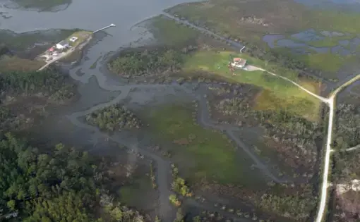
Windsor, however, is just one of numerous areas within the Albemarle-Pamlico estuary forced to contend with increased amounts and days of flooding. The estuarine system, the nation’s second-largest behind the Chesapeake, has 3,000 square miles of open water, encompasses six river basins and eight sounds — the Albemarle, Pamlico, Back, Bogue, Core, Croatan, Currituck and Roanoke — and spans from the central North Carolina coast to southeastern Virginia, according to the Albemarle-Pamlico National Estuarine Partnership. It’s got enough total estuarine shoreline — 9,115 miles — and freshwater rivers and streams — 9,299 miles — to cross the country three times.
In 2006, there were 2.5 million acres of wetlands and 4.5 million acres of farmland recorded, although losses have been steadily occurring over the years since. And it has the largest amount of pocosin wetlands in the world.
To retired East Carolina University coastal geology professor Stan Riggs, the region needs to appreciate the ecotourism “golden goose” that exists in its rich natural resources: miles of quiet waters, hundreds of acres of swamp and forests filled with wildlife and star-lit dark skies unsullied by city lighting.
“People go on U.S. 64 and they go to the beach,” he said in a 2020 interview. “They never get off the highway.”
By promoting the region, its residents will find another approach to making a living with its land and water.
“This is a new resource out there. All of this used to be farming land and timberland,” Riggs said. “Alligator River — we ditched it and ditched it and ditched it. You can’t ditch it anymore because the seas are rising. Because of sea level rise that’s taken place since 1700 … it’s rising now more and more. That water comes up a little bit higher.
“Half of those counties are at sea level — it didn’t used to be that way,” he said. “We can’t farm them. We can’t log them anymore. So, let’s recreate with them!”
Riggs has worked closely with Bertie County officials in helping the community understand its flood risk. But as part of a nonprofit initiative that he chairs, the N.C. Land of Water — the focus is on the 17 counties in the northeast corner of the state, which have been hit with dual stresses of economic decline and environmental challenges from climate change.
“When I started here 55 years ago, there were working people out there on the water,” he recalled. “Everybody had a little boat, they’d go out on these black waters. Those waters are absolutely beautiful. All those streams that come into the Albemarle — awesome, awesome for kayaking. We can bring people from all over the world to paddle these waters.”
An early success in the NC LOW effort is an outdoor recreation project in Bertie called Tall Glass of Water, which recently opened the first public beach in all the Albemarle Sound communities.
But Riggs’ and NC LOW’s shared mission is one of a growing number of efforts to foster coastal resilience.
Reide Corbett, executive director of the multi-institutional Coastal Studies Institute in Wanchese and dean of the Integrated Coastal Program at ECU, has been providing data and, when possible, scientists to local communities to help them mitigate climate impacts.
“I think it’s critical that communities really start thinking about resilience,” he said recently. “Certainly, we need to think about changes we want to have in place after an event. The discussion about what that policy is has to happen before that event.”
But the first step is for a community to define what resilience means to the people there, he cautioned. Is it bouncing back from storm damage? Or is it being proactive about determining responsive options to the impacts of an event?
Being resilient is not simply putting a building back, he said.
“It involves the ecosystem, your economy, the biosphere,” Corbett said. “The concept of resilience needs to think about that interaction, that codependence and the economy that’s built. We have to frame that concept of resilience … That’s important to us, to educate the citizenry. That’s something that we need to do — sort of frame that concept. That’s something that’s done through education.”
Corbett said he is encouraged by Gov. Roy Cooper’s efforts to mitigate climate change impacts and the state’s recent outreach to communities to assist in their resilience planning.
“It’s going to take time to make significant changes,” he said. “We went years, essentially, with no science. We’ve come a long way since 2010.”
One effort that also involves the Coastal Studies Institute — among multiple other universities and agencies in the state and beyond — recently launched is C-Coast, which stands for the Collaboratory for Coastal Adaptation over Space and Time. A North Carolina-focused program funded by the National Science Foundation to address a range of challenges in coastal resilience, C-Coast is a network of coastal researchers, stakeholders and practitioners who collaborate on work that fosters better understanding of human interaction with the natural coastal system.
“We envision C-Coast having perhaps a core of participants,” said Laura Moore, professor of coastal geomorphology at the University of North Carolina Chapel Hill and the director of C-Coast. “But we also see C-Coast as a broad network.”
Even though its initial focus is on North Carolina, she added, the work that’s done will be useful to researchers and stakeholders from other regions.
C-Coast’s “theme,” Moore explained, is “connecting short term decision-making to long-term outcomes, and understanding what are the ways in which the connection between the short-term and long-term can be influenced by different actors in the process.”
As an example, Moore said, when a road is covered in sand during a storm, does removal of the sand — an island’s land — inadvertently weaken the long-term resilience of the island’s landscape?
“We aren’t looking to advocate for any particular outcome or particular future,” Moore said. “We’re looking to understand the decision process, how short-term decisions lead to long-term outcome.”
James “Bo” Dame, professor of biology and physical sciences at Chowan University in Murfreesboro, has involved students in research on water quality impacts, ideally as a way to answer specific questions, such as influences of water quality on submerged aquatic vegetation, or the health of frogs and toads.
Dame said that he is about to launch a water quality monitoring program this spring with his students near the Tall Glass of Water project on the Albemarle Sound in Bertie County.
Although the Chowan River, which empties into the northwest end of the Albemarle, in recent years has been plagued with algal blooms during the warm months, Dame said the problem happens closer to Edenton and has not been evident at the end where they’ll be working.
Their work won’t solve the Chowan’s algal issue, he said, but he hopes it will contribute to improving water quality in the area around the site.
Dame said he and the students will probably be sampling about a half-dozen locations on the northwest edge of the Albemarle Sound from Salmon Creek to the U.S. 17 bridge. Although specifics have yet to be decided, water quality monitoring could be looking at levels of phosphorus, salinity, dissolved oxygen, temperature, or clarity, turbidity chlorophyll, nutrients, nitrogen and phosphorus.
Considering Bertie’s relatively small place in the vast and complex Albemarle-Pamlico estuarine system, Dame said that its active role in resilience planning, economic adaptation and sustainable environmental restoration may be a positive contagion to other communities in the region.
The key to the appeal of Tall Glass of Water, which will include not just opportunities to camp and swim, but also to kayak, canoe and hike on trails, is the combination of environment, ecotourism and especially education, he said.
When Dame teaches his young adult students, he finds them receptive and open to climate issues, he said, but it’s still a battle with education and science literacy.
“This project feeds into that and it provides a perfect opportunity to make young people more aware of their environment, to get them out in the mud and whatever you find outdoors,” he said about Tall Glass of Water. “That’s usually when the lights go on. That’s when they get excited.”