Story
 August 9, 2021
Providence’s Knowledge District Slow to Grasp Reality of Rising Waters
Country:

Project
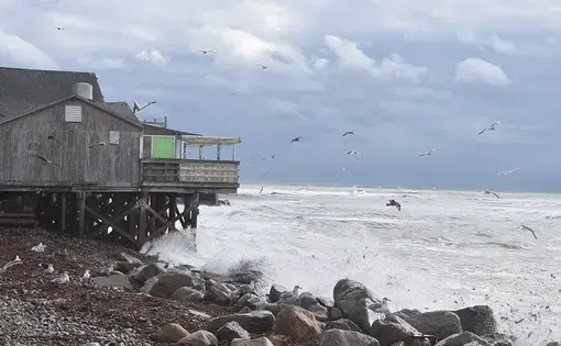
Shifting Sands
Rhode Island is the first state in the Lower 48 with an average temperature rise that has eclipsed 2...


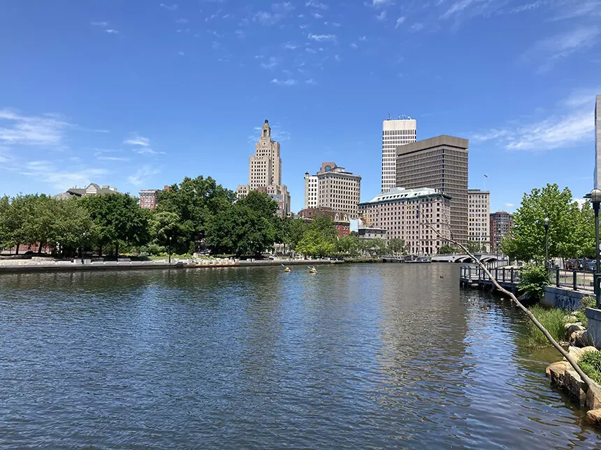
PROVIDENCE — When the sea level rises in Rhode Island, the recently built electric substation in the Jewelry District downtown is prepared.
It has to be. The South Street substation is too important to fail. The gray-paneled concrete box powers downtown Providence, surrounding neighborhoods and four hospitals. It also sits next to the Providence River, a body of water primed for sea-level rise.
National Grid elevated the most-critical infrastructure — the equipment that handles electrical distribution — 8 feet, 6 inches above the existing seawall that lines the Providence River, said Christine Malecki West, a principal architect at KITE Architects, which designed the substation. The approach is not a typical one, she added. But a flooded substation might find itself with damaged equipment or, in the worst case, a fire. Eight and a half feet was simple, Malecki West said, and inexpensive to arrange.
As a nonprofit journalism organization, we depend on your support to fund our nationwide Connected Coastlines climate reporting. Donate any amount today to become a Pulitzer Center Champion and receive exclusive benefits!
Eight and a half feet was worth it.
Across the river, on former Interstate 195 land, Truth Box Inc. architect Peter Gill Case is designing for the same phenomenon in a new apartment and retail building, which isn’t yet constructed. Most of the first floor’s square footage will be a floodable concrete, open-air parking structure. The electrical transformer is on the highest ground the architect could find. The building is prepared, if need be, for a storm surge 22 feet above sea level.
But Gill Case and Malecki West said their decisions to prepare for rising sea levels were not required in any building code, regulation or policy. And without these, many of the buildings in the Jewelry District and the I-195 Redevelopment District are more vulnerable.
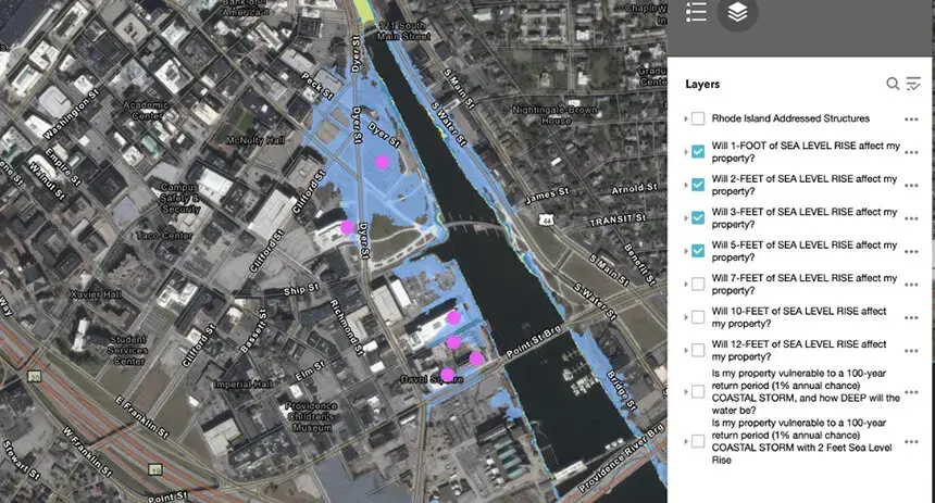


The Aloft Hotel, which is under construction and sits within 600 feet of the Providence River, has a first floor at an elevation of just 6.5 feet, according to public records. The land on which the building sits will flood with just 5 feet of sea-level rise, according to the Coastal Resources Management Council’s STORMTOOLS. At high tide, 5 feet of sea-level rise overtakes the hotel’s first floor.
Of South Street Landing, a building Brown University helped to redevelop in 2017 directly next to the Providence River, Russell Carey, the school’s executive vice president for planning and policy, said, “There are lots of mechanical systems high up in the building, and then there are probably things lower in the building as well. It might not be exactly what you would construct if you were doing it from scratch today.”
He noted most of the buildings Brown University occupies in the area are not prepared “very well” if sea levels flood the city twice daily by 2050, as they are expected to do.
For more than a decade, political leaders have seen the overlapping Jewelry District and the I-195 Redevelopment District as an area for economic renaissance and development. Former governors Lincoln Chafee and Gina Raimondo, former mayor Angel Taveras and current Mayor Jorge Elorza all played roles in advancing development in the area — and giving its sections buzzy names, such as the Knowledge District, The LINK and the Providence Innovation & Design District.
The past three years have finally borne the fruits of these political efforts — with at least five multimillion-dollar developments built in these districts and two still under construction — thanks, in large part, to city and state tax incentives and subsidies. Between them, the state has offered at least $68 million in subsidies, more than $75 million in tax credits and at least $700,000 in tax reimbursements.
To several, the city also offered tax-stabilization agreements, which limits the amount of property tax owners are required to pay. Data gathered by WPRI in 2019 shows that six properties in the Jewelry District with tax-stabilization agreements paid, on average, about half the money that other commercial properties contribute in taxes.
Yet, as dollars are poured into developing the district, the ad hoc preparation for sea-level rise among the various buildings in the area begs the question: How prepared is this burgeoning economic and innovation district to deal with flooding?
The problem will almost certainly impact the Jewelry District and the I-195 Redevelopment District. Both sit adjacent to the Providence River, a tidal body of water that expects, under a worst-case scenario, to see a rise of about 9 feet by 2100. This is the scenario for which the Coastal Resources Management Council (CRMC) is preparing. In the city’s multi-hazard mitigation plan, sea-level rise received a score of four out of four for probability — “because we know that [it] will absolutely impact Providence in the future,” according to city spokesperson Ben Smith, who recently accepted a similar job with the state treasurer.
In the 2019 plan, the city noted that nearly $1.6 billion worth of land, buildings and other properties is vulnerable to mean higher high water plus a foot of sea-level rise. Five hundred more land parcels would be impacted by 7 feet of sea-level rise, increasing the total value at risk to $3 billion.
“Why does it matter?” asked Greg Gerritt, of the Environment Council of Rhode Island. “It matters because our communities will be affected severely if those buildings get severely damaged by rising sea levels. It’s a waste of resources that we shouldn’t have wasted. … If you’re all in on an economic development strategy around luxury buildings, god---- it, do them right at least, so that they don’t fall apart and waste all that tax money that we gave them.”
False sense of security
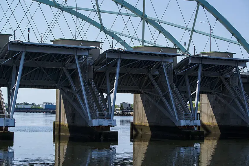
At the mouth of the Providence River sits the Fox Point Hurricane Protection Barrier, the first gated hurricane-protection structure in the United States. The hulking structure, rather elegantly engineered as part of I-195, can protect low-lying downtown from storm surges of up to 20 feet above mean sea level by lowering its steel gates and making an impenetrable wall against water.
Well, almost impenetrable.
“The hurricane barrier was not designed to address sea-level rise,” said James Boyd, a coastal policy analyst and CRMC’s deputy director.
Boyd and Pam Rubinoff, a coastal management specialist at the University of Rhode Island’s Coastal Resources Center, worry that the 700-foot-long, 25-foot-high barrier — the highest in the country — gives the city a false sense of security. Since it’s meant to protect downtown from major coastal storms, why can’t it protect it from sea-level rise?
“It is not a tidal barrier,” Rubinoff said. “People might perceive that they’re protected from sea-level rise because of the barrier, but the barrier is designed for coastal storm surge.”
Using the barrier to protect against rising sea levels would mean gradually having to close it more and more often, to keep high tides out. On top of being expensive — it costs about $2,500 each time it’s closed — the structure wasn’t designed for such frequent use.
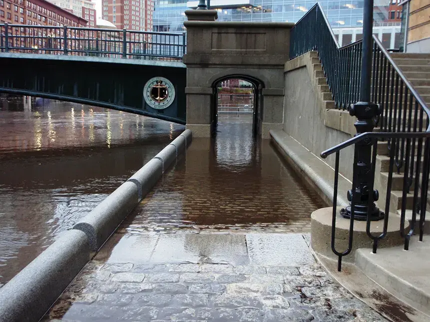
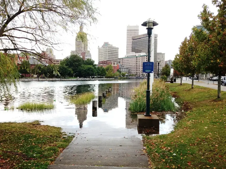
For now, though, that’s what the city is relying on. The coastline in Rhode Island has already experienced about 10 inches of sea-level rise since 1930, and the Army Corps of Engineers has to close the Providence hurricane barrier about 10 times a year to handle unusually high king tides, which closely portray what a normal high tide will look like after a foot of sea-level rise.
Without the barrier in place, king tides can now cause “sunny day” flooding along the Providence River and in Waterplace Park. Tide heights in Providence that prompt a precautionary closing of the barrier are predicted to occur more than weekly by 2050 and twice daily by 2100.
Commercial development, like the type taking place in the Jewelry District and I-195 Redevelopment District, typically has a lifetime of 30-50 years, Boyd said. These buildings, many completed in the past three years, could undergo weekly flood risk before their use ends.
But many buildings in these districts are looking at even longer time frames. The electric substation is built for a 100-year horizon, Malecki West said. Brown University has invested more than $200 million in the area throughout the past decade. The university now owns 11 buildings and leases seven. The long-standing institution “has a full expectation of continuing to fulfill our mission for the infinite future,” Carey said. “Typically buildings that the university builds are often fifty to one hundred year buildings.”
At 5 feet of sea-level rise, six of those buildings are vulnerable to flooding, according to STORMTOOLS. Three — River House, South Street Landing and the Wexford Innovation Center — were built in the past three years.
But the hurricane barrier goes one step further in perpetuating the status quo. In 2009, the Fox Point Hurricane Protection Barrier and its levee system was accredited by the Federal Emergency Management Agency (FEMA), which meant it was expected to provide flood protection against 100-year storms for properties upriver.
Buildings behind the barrier, if in a flood zone at all, are in zone “X” — an area with reduced flood risk because of the levee system. These properties aren’t required to buy flood insurance, according to Joseph Dwyer, a risks and hazards planner at the Rhode Island Emergency Management Agency. And because these properties aren’t technically in a “flood hazard area,” the state building code that requires proposed new construction to minimize flood damage doesn’t apply.
Malecki West, when asked if she was concerned that this situation may leave buildings in the area even less prepared for sea-level rise, said, “I’d say yes. It’s a logical conclusion.”
Flood protection
Without FEMA’s flood maps to ensure that buildings in the Jewelry District and I-195 Redevelopment District take sea-level rise into account, a few Rhode Islanders waged their own battles to ensure it would be.
Arthur Salisbury, architect and president of the Jewelry District Association until 2018, was originally part of the design team that selected the architect for the Providence River Pedestrian Bridge. His team discussed raising the bridge a foot and a half to prepare for sea-level rise. Salisbury prevailed — in 2016, the bridge’s design was raised 18 inches.
Meanwhile, Gerritt spent 2018 and 2019 opposing the Hope Point Tower, also known as the Fane Tower, a 46-story luxury apartment complex that would sit about 500 feet from the edge of the Providence River. The building went through a drawn-out and highly public permitting process, largely because of its height, and was eventually rejected by the city’s Downtown Design Review Committee (DDRC) in April 2019.
“I remember very clearly saying that you build this building and in not all that many years it’s going to be inaccessible because of sea-level rise,” Gerritt said.
But Gerritt ultimately lost this battle. Despite being rejected by the DDRC, the I-195 Redevelopment District Commission approved the tower design five months later, overruling the city’s decision.
“I said that they ought to be ashamed of themselves because none of their buildings are really ready for climate change,” Gerritt said.
After plans to relocate I-195 emerged in 2009, the state created the redevelopment commission two years later to sell the newly uncovered land and oversee its development. The commission doesn’t have any requirements for buildings with regards to sea-level rise — in spite of a statement from the then executive director, Jan Brodie, in 2015 that sea-level rise and storm surge would be addressed in any development project.
“We don’t set the building codes, so we’re not requiring what the building has to have in it,” said Caroline Skuncik, current executive director of the I-195 Redevelopment District Commission.
Skuncik added that “the most vulnerable areas we own are restricted as parkland,” pointing out the new Providence Waterfront Park along the Providence River. The Hope Point Tower, however, replaced a portion of the park with private development.
In a call for request for proposals sent out last year, the I-195 Redevelopment District Commission asks developers to include descriptions “of any elements that enhance the project’s resiliency to the impacts of climate change.”
Large-scale adaption
CRMC is the only agency in the state to require the consideration of sea-level rise when constructing new coastal buildings and structures, and its decision to do so is recent. The agency’s coastal hazards application worksheet, released in 2019, makes coastal property owners learn how sea-level rise will impact their project in years to come.
CRMC’s jurisdiction, however, ends just 200 feet inland — far short of where sea-level rise (SLR) will ultimately reach — and property owners aren’t required to take the results into consideration when designing. But the agency hopes the online application helps address the issue in other ways.
“We designed it so that if a municipality chose to use this same process at the local level, they could,” Boyd said. “So we’re encouraging the 21 coastal communities to adopt this.”
But the city of Providence, and the Ocean State’s other 20 coastal municipalities, haven’t adopted the coastal hazards application into their own permitting, Boyd said.
When asked if Providence adopted the CRMC application process, Smith, the city’s deputy director of communications, wrote in an email that, “Sea level rise is an issue that we take very seriously, and the City would be willing to institute any measures that may be applicable to Providence. The City continues to partner with state and federal agencies dedicated to mitigating the impacts of climate change and SLR on our community.”
The state doesn’t include the CRMC hazard worksheet into its building code, either, despite legislation that requires the building code to “take into account climatic changes and potential climatic changes and sea level rise.” As for buildings in the I-195 Redevelopment District, which fall under state jurisdiction instead of city, developers are made aware that CRMC “may come back and request that developers complete the Coastal Hazard Application and Form,” according to Cara Cromwell, a spokesperson for the I-195 Redevelopment District Commission.
Since 2015, Boyd has been pushing those building in the I-195 Redevelopment District to prepare for at least 3 feet of sea-level rise. But so far, not a regulation exists that requires property owners in the Jewelry District and I-195 Redevelopment District to do so.
In fall 2019, the city of Providence released a Climate Justice Plan, co-created by the Office of Sustainability and the Racial & Environmental Justice Committee. The plan, above all, revolves around collaborative governance and community involvement, so decisions about the next steps for Providence and its rising sea levels are made collectively, according to Leah Bamberger, the city’s director of sustainability.
“I would say in the next ten years or so, that’s when the city should be starting to have that community-wide conversation about what is our vision for the long-term impacts of climate change,” she said. “Specifically around sea-level rise and protecting all of the coast, not just downtown, but down to where Save the Bay is.”
The city may have to choose between investing in seawalls, which would change the character of the river-centered city, or accept periodic flooding. Analysis by the Center for Climate and Energy Solutions and Johns Hopkins University found that the most cost-effective approach would be to raise the threshold at which the hurricane barrier is shut and prepare the waterfront to be periodically flooded.
If an individual building adjusts for sea-level rise, without the community doing so too, “what good is that?” Bamberger said. “How are people going to get to you? How are the utilities going to access your building? Are you going to have power? It really needs to be thought of as a much larger scale.”
Sixty-one critical facilities will be impacted by 7 feet of sea-level rise at mean higher high water, according to the city’s multi-hazard mitigation plan. These include two pieces of wastewater infrastructure, four health-care and/or hospital buildings and four energy facilities.
Keeping all of these safe from sea-level rise will take a “real coordinated strategy,” said Austin Becker, an associate professor and director of graduate programs in URI’s Department of Marine Affairs. “There’s no point in elevating the first floor of a building if the infrastructure [around it] isn’t elevated too.”
That type of large-scale adaptation, he noted, requires coordination at the city, state and national levels.
“These are called wicked problems,” he said. “We need some real funding behind this to really try to understand what some options might be, and we need to do it now.”