

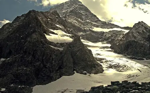
Kashmir, the ruggedly beautiful mountainous region that lies along the India-Pakistan border, was...

While people across the globe are becoming more aware that the glaciers in the western Himalaya are receding, few know how information about the glaciers, weather systems, and river levels in remote regions of the world like Kashmir are gathered. Cut off from the world the better part of the past two decades, due to a bloody conflict, the region's glaciers could only be monitored through remote sensing (satellite images). But as relative peace returns, scientists are for the first time able to conduct field research on the glaciers. Recently an expedition team traveled to Kolohai, one of the largest glaciers in Kashmir. Kolohai, which literally means "high altitude stream," is a lifeline for millions of people in Kashmir and Pakistan who depend on the streams and rivers it feeds. But these waters, and the people who rely on them, are in jeopardy.
Monitoring the Melt
"Today we are going to dig snow pits on the accumulation zone, at the top of the glacier," explained Dr. Shresth Tayal, 32, a glaciologist hired by The Energy and Resource Institute (TERI), as he strapped ice clips to his boots. It was six o'clock in the morning and freezing but Dr. Tayal was already up organizing his gear for the day's climb.
"Think of this glacier as a huge bucket with a hole in the bottom," explained Dr. Tayal's assistant, Nathaniel Dkhar, 23, a witty young man with an uncanny ability to translate scientific terms into layman lingo. "If you have more water going out than you have coming in, you have a negative mass balance, and the glacier is shrinking. That's exactly what's happening to Kolahoi and thousands of other glaciers across the Himalaya." The latest data from TERI showed that in the last four decades, Kolahoi has lost between 15 to 18 per cent of its total volume and is now going down by almost three meters a year.
Using the most basic equipment the expedition team, which consists of two glaciologists, three journalists, and two-dozen mountain guides and pony wallahs (men who hire their ponies to haul supplies) trek for nearly two days to the base of Kolohai. All of the gear and provisions for the expedition, including a dozen live chickens (that will later be in the cooking pot), are hauled up the mountain on horseback. With only a generator (which works occasionally) for electricity, no satellite phone, inadequate sleeping bags, and tents, there are few luxuries. But even with limited supplies the team is able to conduct their measurements.
The method for measurement goes something like this: They first drill a series of holes in the ablation zone or established melting area and then take pre-measured sticks (literally bamboo poles) and place them in the holes. After each melting season, the team will measure the length of the pole exposed, take notes, and repeat the procedure. The process may sound elementary but it's extremely tedious and labor-intensive. Much of the cutting and drilling takes place at heights of 13,000 feet on icy crevasses where a mishap could mean severe injury or even death.
Despite the risks involved, Dr. Tayal says he loves the adventure of his job. He believes there needs to be a greater push to get young people involved in the sciences in India. "India has had its economic, and technological boom, now it needs to have its scientific boom," he says. "The government needs to encourage young people to pursue higher education and jobs in the sciences." He said the measurements taken at Kolahoi will have a global impact.
From NASA to Weather Stations
"We do not have much reliable data on the western Himalayan glaciers," he says. "If you want to know what the global impact of climate change is going to be and make accurate projections, you can not exclude the Himalaya from the Rockies and the Alps."
In addition to monitoring Kolahoi, the team made a profile of the glacier through its Differential Global Positing System (DGPS). NASA is now looking into the possibilities of building a partnership with TERI, as the data collected through TERI's (DGPS) system could be used to give more accurate readings for NASA's maps. In addition to monitoring the glaciers, the expedition team also set up an "Automatic Weather Station" (AWS). The station is powered by solar panels and measures the parameters of weather around Kolahoi. As weather patterns and temperatures continue to change in the area, the (AWS) will give the most accurate readings.
According to Action Aid, in the last two decades the average temperature in Kashmir has gone up by 1.45 Celsius and is expected to annually rise by half a degree. Snowfall throughout Kashmir has decreased, which has already resulted in changes in water levels.
Waning Waters
In an effort to get a comprehensive account of the melt water in the Liddar Valley, TERI established a "Discharge Monitoring Station." The station will measure the water levels in the West Liddar River, which is the main tributary of the Jhelum River, one of the largest rivers in Kashmir and Pakistan. Each day this station collects data that feed into much larger reports like that of the Woodrow Wilson Center which states, that as the glaciers in the western Himalaya disappear, the waters coming into Pakistan from Kashmir will drop by 40 per cent.
"The data we collect from small streams like Liddar help us get a better understanding of the bigger picture of how water levels in India and Pakistan will be affected by climate change and provides information for a much larger international projection," said Tayal. "One of the greatest threats facing Kashmir and Pakistan will be disputes over water. What we are seeing here at Kolohai are the early signs of a looming water problem."
In a region as politically fragile as Kashmir, the changes in water levels could have devastating effects on a place and people that have only begun to recover from conflict.