Story Photo District News November 27, 2019
Alex Maclean’s Aerial Photos of Sea Level Rise
Country:


Project
East Coast Sea Level Rise
There is no denying that sea level rise will result in catastrophic damage along our coastlines. Sea...
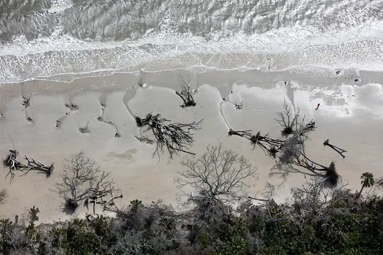
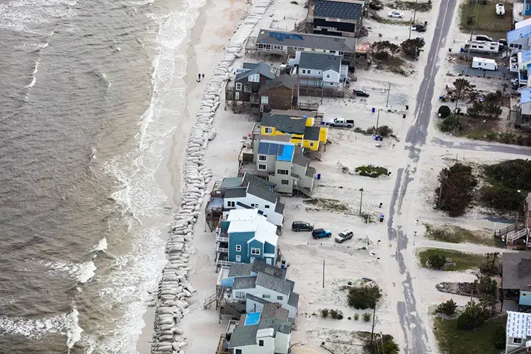


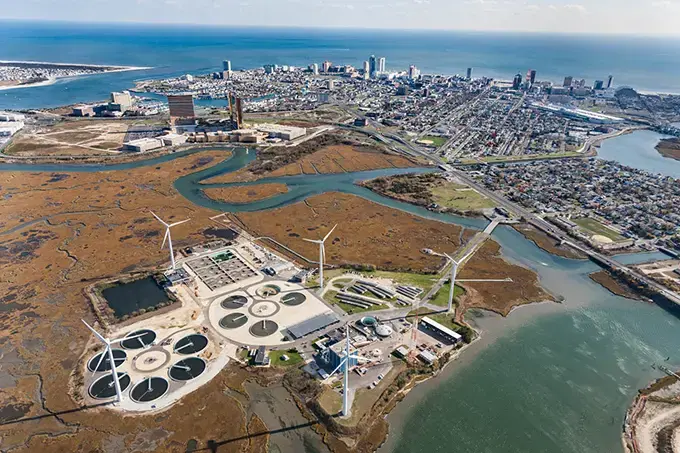
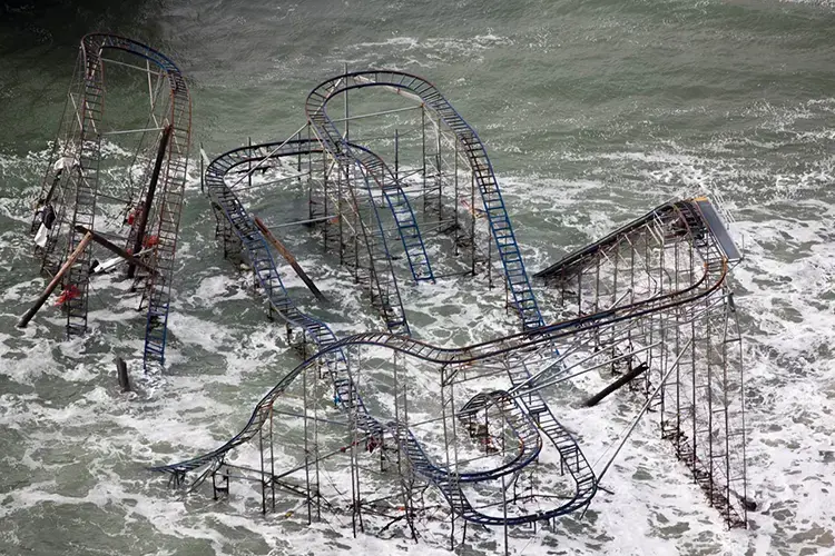
At close range, evidence of rising sea levels can be sporadic and difficult to see. From an airplane at 1,000 feet, though, the implications and effects take on more urgency. Photographer and pilot Alex MacLean raises the alarm in Impact, his new book of aerial photographs showing communities and infrastructure along the Eastern seaboard and Gulf Coast that is vulnerable to storm surge, floods and other extreme weather.
“The bottom line is we should start building awareness” about climate change and the risks from rising oceans, MacLean says. “We should reduce our carbon emissions and take it seriously. That’s the idea of the book: showing this vulnerability. We’ve really got to take it more seriously than we do.”
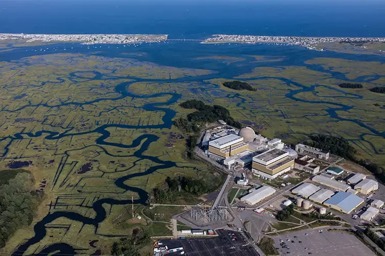
MacLean’s aerials show beaches eroding, and dunes, vegetation and houses washing away. They show rail lines, sewage treatment facilities and nuclear power plants built on wetlands, one storm surge away from disaster. The book serves as an indictment and a warning, but MacLean pulls viewers in with the beauty, drama, and plenty of golden light.
Published in French by Éditions Dominique Carré in Paris, Impact is the most recent in a series of books by MacLean about built environments and climate change. His previous books include Over (2008), about energy- and resource-intensive land development in the U.S.; Above and Beyond (2002), about suburban sprawl; and Up on the Roof (2012), about outdoor spaces and gardens on Manhattan rooftops. MacLean said he was in a quandary about the subject of his next book. “It was a toss-up between looking at agriculture in relationship to climate, or looking at sea level rise,” he says.
MacLean made a decision in 2018, while on assignment to shoot aerial photographs of Central Park for The New York Times. Piloting a plane from Boston to New York, he flew along the coasts of Massachusetts, Rhode Island and Connecticut. It was “just to get a feel for what it would take to document the shoreline around sea-level rise issues,” says MacLean, who received funding for the project from the Pulitzer Center on Crisis Reporting. “There were definite features I was looking for”—such as housing developments along spits and barrier islands—“but a lot of it was discovery of things I had not anticipated, like realizing the Amtrak line goes through coastal wetlands, and is incredibly vulnerable.”
MacLean began photographing the coast from Maine to Florida, and eventually the Gulf Coast, too. “As I went along, I learned so much by observing,” he says. “You see something, circle it, photograph it and move on.” For most of his flights, he piloted a Cessna 172. Shooting photographs at the same time made it “a bit like doing acrobatic flying. You’re flying carefully and precisely. The big thing is you have to look around for traffic. Often if I’m in a congested area, I’ll work with flight control. They’ll advise you of your traffic.”
MacLean shot with a Canon 5DS R, using prime lenses ranging from 24mm to 400mm. “You always shoot for the light,” he explains. “In the middle of the day, you can make an ugly parking lot really ugly. But in general I prefer the warm light, with the sun 20 degrees above the horizon or lower.”
A perennial challenge with stories about environmental disaster is overcoming viewer fatigue, and keeping audiences engaged. “One way to do it is look at positive things being done to reduce carbon outputs,” says MacLean. “With sea level rise, looking at ways to mitigate [the problem] through natural systems is another way of engaging people instead of just beating them over the head with disaster stories. I think you have to do a little bit of both.”
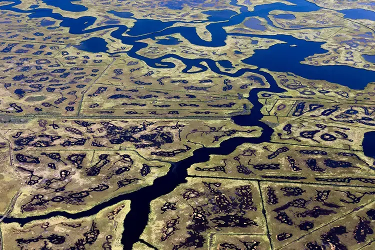
For instance, MacLean photographed restored oyster reefs, as well as sand dunes that had been planted with vegetation in order to strengthen the dunes and protect low-lying areas against storm surges. “It’s an unobtrusive way of trying to stave off the immediate impact” of rising sea level, MacLean explains.
But the best solution is to reduce carbon emissions, he emphasizes. MacLean readily acknowledges his own contribution to climate change. “I do a lot of flying and I feel a lot of flying I have been doing can be taken over by drones, which can be a good thing,” he says. But he had to explore 2,300 miles of coastline quickly to produce the book, and drone photography would have been impractical and slow, he explains. “It would [have been] hard to move around on the ground, set up a drone and photograph. There’s a sense of urgency in getting [the message about sea level rise] out.”
Éditions Dominique Carré has published several of MacLean’s previous books. “[They were] enthusiastic about taking on another book project with me. That made it easy. I didn’t have to go around selling the project and work with someone I’m not familiar with,” MacLean says. Moreover, his books can be a tough sell to U.S. publishers because of what MacLean describes as “a somewhat negative spin” on land use and culture here in the U.S. “It’s easier to point fingers at Americans and the way they live, and maybe even take a bit of delight in doing that,” he says of his more receptive European audiences.
MacLean is still hoping to find an English language publisher for Impact. Meanwhile, he is turning his attention to his next project, about the U.S. agricultural system and its relationship to climate change. For that project, MacLean says he expects to reduce his carbon footprint by doing less flying, and more drone photography instead.