

How Virginia's mountain communities are meeting an uncertain climate moment

Warmer air is fueling heavier downpours across the country, but the systems used to measure flood risk are outdated and unevenly distributed.
Richard Mabry’s first warning that he needed to evacuate came from the large rocks crashing through the woods on the slope above his house. “I thought the whole mountain was coming down,” says Mabry, who lives in a deep Appalachian hollow next to a creek. “Big boulders came out, and then it just gushed.”
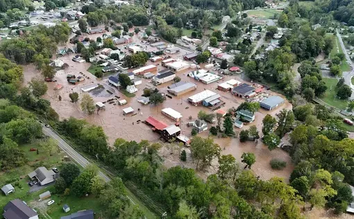
An isolated thunderstorm had cropped up over his home of Dante, Virginia, on a sunny Sunday afternoon in July 2025. The ground was wet after several days of rain, and without warning, the tiny former coal town began to flood.
Richard fled, as did his older brother James, with their 100-year-old mother Lillie. Richard went uphill, the long way out. James, who at 77 had experienced about five floods there before, went the direct way through town, where the water was rising. But his truck got stuck in the flood at the bottom of their road, forcing him to climb out of its window. Lillie, who is frail but stalwart, laid down and slid through the truck’s back window headfirst into James’s arms. Then he carried her along the train tracks to the safety of their church on higher ground.

As a nonprofit journalism organization, we depend on your support to fund more than 170 reporting projects every year on critical global and local issues. Donate any amount today to become a Pulitzer Center Champion and receive exclusive benefits!
“I lost my vehicle in the flood,” James says; although he had driven through flooding about that high before, he suspects the water must have been moving faster this time. He says this flood was the only one in his lifetime to take down the heavy concrete bridge behind the house where Lillie had grown up and then raised James, Richard, and their five other siblings. “It took us about a week or two to clean the mud out of our house,” he says.
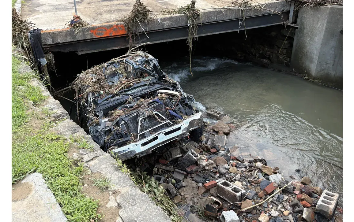
Behind James’s vehicle, their neighbor Tina Sanders and her fiancée also got caught in the water. Although they had gotten out of the windows, their lighter truck began to float. They were sucked into a tunnel under the railroad tracks. Where the current slowed in the center of town, her partner pulled himself out of the water, but Tina couldn’t. She was pulled into a hole where the pavement had collapsed and buffeted by the rapid floodwaters, before emergency responders could get to her. “I don’t know how long I was under there,” Sanders says. “I was beaten and banged and the Lord got me through it.”
As in many mountainous places prone to flash floods, flood prediction is difficult for local emergency responders in Russell County, where Dante is located.
“Every possible high-risk flood situation is piled into a very small area with very steep terrain—and very low tax revenue."
While Sanders and the Mabrys were evacuating this life-threatening flood, the weather was placidly sunny in the county seat of Lancaster. By the time Russell County administrator Lonzo Lester and other emergency responders got the call telling them about the flooding in Dante, the quickest roads into the isolated community were no longer passable. Instead, they had to use utility terrain vehicles to drive in on the railroad tracks. When they arrived, downtown Dante was underwater.
“The first emergency within minutes after we got there was a house that was coming apart,” Lester recalls. “There were two residents there. We had to evacuate them.”
Meanwhile, others were getting to Tina. They pulled her out at a bridge on the other end of town, just as she was losing consciousness. She was taken to the local hospital, where she got staples in her head wounds and was treated for pneumonia. Amazingly, she had no broken bones, and she recovered.
Ultimately, 21 people lost homes. Remembering the flood, Lester’s relief that they saved everyone is palpable. “As many that went into the water, and the vehicles and the houses that got touched, we didn’t lose one life,” says Lester, who grew up in neighboring Buchanan County, where flash floods are also a known risk.
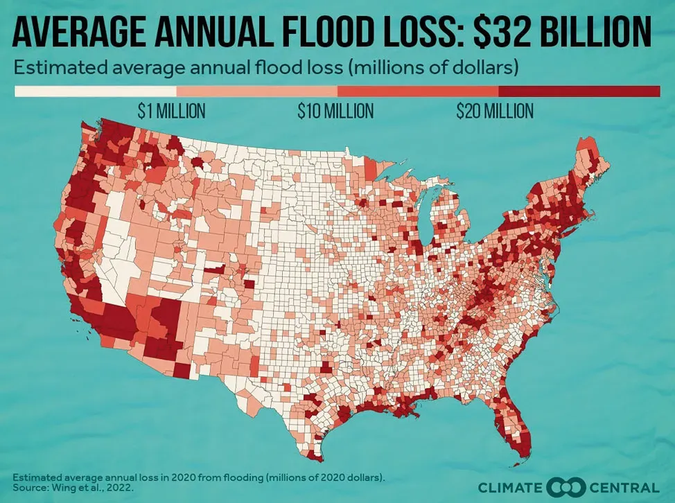
Lester knows how tough flood preparation can be here. As climate change is intensifying and worsening extreme rainfall, it’s getting even harder. Hurricane Helene, several bad winter storms, a February flood, and this July flood all occurred within a year of one another, each compounding strains on resources. According to the nonprofit research group Climate Central, Virginia’s annual flood losses are expected to increase 19 percent between 2020 and 2050, to well over $1 billion. Southwest Virginia is one of the most affected regions, despite its distance from the coastal areas where sea level rise has garnered headlines.
“In this region, every possible high-risk flood situation is piled into a very small area with very steep terrain—and very low tax revenue,” says Erin Rothman, chief scientist and cofounder of Mērak Labs, a company that helps local governments with flood resilience projects such as improving hazardous weather prediction. Through a program from the nonprofit RISE Resilience Innovations, Rothman helps low-tax-revenue counties conduct the research needed to prioritize flood resilience strategies, apply for grants, and respond to emergencies. Rothman is currently helping two flood-prone counties in Southwest Virginia, Buchanan and Dickenson Counties, each adjacent to Russell County.
In the Data Gap
McKenzie Tate, a recent graduate of Virginia Tech, grew up about a 40- minute drive away in Norton, Virginia, where she witnessed rapid flood damage in her childhood home and surrounding neighborhood. When she was in elementary school, a flood from high rainfall and poor drainage caused property damage at her next-door neighbor’s house. “The wood floor was so squishy,” Tate recalls. “Every time that we would take a step, water would pool up.”
When she was about five, she remembers water flooding her family’s basement coming up to her knees. And in February 2025, water entered their basement again, so she returned home from college to help clean up. These experiences inspired Tate’s interest in meteorology. For her senior thesis, she teamed up with her advisor Craig Ramseyer, a geographer and meteorologist at Virginia Tech who grew up in nearby Abingdon.
“We originally were going to compare how radar data are performing with observation data,” Tate explains. The radar maps shown on local weather forecasts are derived from radar data at specific locations extrapolated across geographical areas using computer algorithms. Errors in those models are adjusted using ground-level data from electronic rain gauges that report readings at least hourly.
But when Tate tried to look at that rain-gauge data, she could barely find any. For example, the town of Grundy, Virginia, is located in an area with so many bad floods that the entire town was moved during the 2000s, but it is 60 kilometers from the nearest rain gauge, which was set up in Norton by the National Oceanic and Atmospheric Administration (NOAA).
“Mountains and valleys change the micrometeorology,” Ramseyer says. “What’s happening in Norton is not at all representative of these smaller flooding threats.”
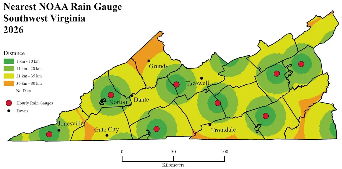
Given these issues, Tate changed her project goals. “We pivoted to looking at the data inequity issues,” she says. “There’s not a lot of good, high-quality data in southwestern Virginia—or really in most of central Appalachia.” She presented her findings at the American Meteorological Society’s annual meeting in Houston in January.
Given these issues, Tate changed her project goals. “We pivoted to looking at the data inequity issues,” she says. “There’s not a lot of good, high-quality data in southwestern Virginia—or really in most of central Appalachia.” She presented her findings at the American Meteorological Society’s annual meeting in Houston in January.
Tate and Ramseyer found that Southwest Virginia is in an observation gap: It is far from radar stations, and lacks enough gauges to catch the errors that are likely occurring in precipitation estimates. Areas where flood risks are pervasive and worsening, and where minutes matter to protect people, don’t have sufficient weather data.
Working with What You’ve Got
To complicate matters further, the rain gauges in the NOAA dataset that Tate looked at are not necessarily the only ones out there. Rothman helps towns and counties compile all the relevant data to assess their flood risks and whether they want to set up rain gauges of their own. There are private rain gauge networks, such as one called Tempest. In addition, Rothman says, “National Weather Service has some information, NOAA presents some information, USGS [U.S. Geological Survey] presents some information, and VDEM [Virginia Department of Emergency Management] presents some information. But nobody consolidates everything in one spot, which is mind-boggling.”
Nobody consolidates all of the rain-gauge data into one spot, which is "mind-boggling."
On top of those problems, publicly available flood risk maps from the Federal Emergency Management Agency (FEMA) are insufficient for assessing flood risks. Not only are they based on older data that do not account for climate change, they also do not factor in vegetation and pavement, which also change flood risks. For example, Tate’s neighborhood began experiencing worsening flooding as development at the top of its steep hill progressed, without changes to the storm drain system.
“We pull together a lot of spatial information, looking at land cover, tree canopy, elevation, and flow paths,” Rothman says. “We consolidate all of that to identify areas where flooding is most likely to occur, and if so, whether it’s high-velocity flow or not.”
By combining all these datasets into one model, Rothman helps governments with their emergency response capabilities. “We were able to identify the February storms last year that were pretty horrible before the Weather Channel notified that they were happening,” Rothman says. It was during one of those storms that Tate’s family basement flooded—but not in a county where Rothman is working in yet.
“In any community, the more development that you have, the more tax revenue you envision. So, you’re focused on the economic components of new growth,” Rothman says. “But oftentimes if you move too quickly, or you don’t consider the full cost–benefit of new growth, you’re going to be dealing with a lot more pavement and a lot more water to manage that you didn’t consider in the first place.”
These kinds of analyses have long been out of reach for low-tax-revenue governments. But with nonprofits like RISE, along with lowering technology costs, things are changing. “Whether we like it or not, AI is what’s allowing us to do this,” Rothman says. “Instead of hiring consultants for $200 an hour to spend half a million dollars putting together a flood map, we can use the tools that are available to us, and it’s orders of magnitude more cost-effective.”
Plugging the Data Gaps
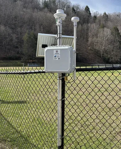
During the July 2025 flood in Dante—the one Sanders and the Mabrys survived—the existing rain gauge data at the time was from too far away to help at all. Comparing the precipitation estimate with and without the rain gauge data showed no difference. That means there’s no way to know whether the radar model’s estimate of 3.1 inches of rain was erroneous—or by how much.
In May 2026, the Virginia Department of Emergency Management established a new rain gauge in Dante, at a ballpark just above the area that flooded. Next time, the precipitation estimate will be more accurate, and meteorologists and emergency responders will get quicker notification of extreme rainfall there. It’s one step in filling the observation gap in the region.