Story Publication logo September 6, 2023

Commuter Town

Country:

Authors:
English

This project will look at three vulnerable groups of workers: domestic workers, commuters, and...

author #1 image author #2 image
Multiple Authors
SECTIONS

Image by Matilde Campodónico. Uruguay, 2023.

Léalo en español.

Leia em português.

From Drought to Floods: San José

A large part of the population of Ciudad del Plata will be affected by the flooding projected by the Ministry of Environment due to climate change. In this investigation, Amenaza Roboto used the latest technology available to visualize the impact on the population and ecosystems as accurately as possible.


A large part of the population of Ciudad del Plata will be affected by the flooding projected by the Ministry of Environment due to climate change. In this investigation, Amenaza Roboto used the latest technology available to visualize the impact on the population and ecosystems as accurately as possible.

Climate change is not the only factor affecting the environment. Human activity also brings about new approaches to land use, with changes in the population, its habits or its expansion often tied to the supply of labor. In an area with a growing population and conditions prone to flooding, technology makes it possible to visualize risks in order to plan solutions.


As a nonprofit journalism organization, we depend on your support to fund more than 170 reporting projects every year on critical global and local issues. Donate any amount today to become a Pulitzer Center Champion and receive exclusive benefits!


Child and Family Care Center (CAIF) recreated by LiDAR. Image courtesy of Amenaza Roboto.

Poorly constructed housing in the flood-prone area of Delta del Tigre. Image by Matilde Campodónico. Uruguay, 2023.

The Case

Ciudad del Plata is one of the localities with the highest rate of population growth in Uruguay. According to census data, the suburb grew 808% between 1963 and 2011. Diego Aboal, the director of the National Institute of Statistics, has projected that the 2023 census will indicate another leap of "explosive growth" in the area.

Much of this growth can be explained by its geographic proximity to Montevideo: With a relatively lower cost of living, Ciudad del Plata offers its 31,000 residents the opportunity to access the job market in the capital while living in a city located 22 kilometers away.


The Air Liquide industrial plant is located in a flood-prone area, according to the study conducted by the Institute of Environmental Hydraulics at the University of Cantabria, commissioned by the Ministry of Environment of Uruguay. Image by Matilde Campodónico. Uruguay, 2023.

Ciudad del Plata has the highest number of inhabitants employed outside of their locality in the metropolitan area: 46%, according to the 2011 census.

Because of this growth, what used to be several population centers are now neighborhoods of the same big city. Some of the best known are Delta del Tigre, Penino, Autódromo Nacional, Playa Pascual and Ciudad del Plata itself.

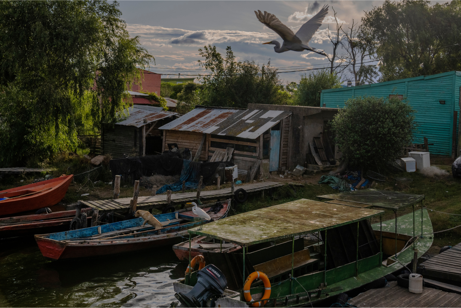
Two thirds of the population of Ciudad del Plata lives in Delta del Tigre, a flat area with a high risk of flooding. At its highest point, the sector barely reaches six meters above sea level. Floods due to ineffective storm drainage, tides and sudestada, "southeasterly," winds are common, and these events are compounded by the risk of flooding due to abnormal rainfall in the upper basin of the Santa Lucía River.

The Ministry of the Environment projects that a large part of this area could potentially be flooded as sea levels rise, affecting the lives of a large part of the population in this commuter town.

The Penino Beach and Autódromo Nacional neighborhoods face a similar fate.

Results


Map courtesy of Amenaza Roboto.

This article focuses on two areas of the population of Ciudad del Plata: Delta del Tigre and Penino-Autódromo. The Ministry of Environment projects for 2100, and before extreme events, that these areas could be flooded.


Map courtesy of Amenaza Roboto.

Approximately 200 hectares of flood plains in the Delta del Tigre area would be filled with water, displacing 3,671 people (1,908 women and 1,763 men) from their homes. In several areas the water would completely submerge homes, causing them to be temporarily vacated.

Similarly, in the 200 hectares of the Penino-Autódromo coastal area, there were 1,446 people living there in 2010, distributed evenly between women and men (720 and 726, respectively). In the event of a potential sea level rise due to climate change, 80% of the population (1,157 inhabitants) in the area would be displaced and their homes would be almost entirely underwater.

Between the two regions, 4,828 residents in an area covering 415 ha would have to be evacuated.


Map courtesy of Amenaza Roboto.

The Penino and Autódromo Nacional neighborhoods are characterized by simple concrete structures and smaller, informal settlements without access to sanitation. Delta del Tigre is divided between a sector of simple concrete houses and one with larger, more expensive residences with wharfs for boats of different sizes.


Since its inception in 1988, the CAIF Plan has been an important public policy that seeks to establish intersectoral collaboration between the central government, civil society organizations (CSOs) and municipalities. Its purpose is to ensure the safeguarding and promotion of children's rights from conception to 3 years of age. This approach especially prioritizes access to services for children from poor or socially vulnerable families, covering both urban and rural environments. Image by Matilde Campodónico. Uruguay, 2023.

As the 2011 census report of the National Institute of Statistics points out, "internal migration is the component of the demographic dynamics that most heavily influences the differences in population growth observed by department. The three departments with the highest population growth between 2004 and 2011 (Maldonado, Canelones and San José) are the ones that have had a positive migratory balance since 1996, being also the only ones with a percentage of the population born in another department higher than the national average."

Continuing this trend, recent communications of the preliminary results of the 2023 census indicate a significant population increase in Ciudad del Plata as a result of population migration from Montevideo and surrounding areas, so it is highly likely that the number of people affected will exceed the expected figures.This study allows us to not only visualize how many residents will be affected by flooding, but also how their homes will be affected. The 3D model helps to identify the height of water levels on the beach, dune ridges, nature reserves, industrial areas and schools.

Ciudad del Plata - CAIF with flood projection. Video by Amenaza Roboto.
Ciudad del Plata - Air Liquide with flood projection. Video by Amenaza Roboto.
Ciudad del Plata with flood projection. Video by Amenaza Roboto.

Under the projected climate scenario, at least two population centers will be submerged. The Penino Beach Nature Reserve will see the dynamics of its ecosystem affected, impacting the life cycle of its fauna and flora. Birds that used these areas as stopover points may see changes in their migratory trajectory. The waste management routine and operations of the surrounding chemical industries will have to be modified. Notably, Delta del Tigre's educational centers and school canteens are located in flood zones.

Identifying the effects of these flooding phenomena allows us to take action to prevent a greater impact on the population and ecosystems. New mitigation measures and land-use plans can be generated from this study. This work is intended to be used as a tool for all these actions.


School 96 has 562 students, according to ANEP's Education Monitor. Image by Matilde Campodónico. Uruguay, 2023.

How it works: High resolution mapping

LiDAR (Light Detection and Ranging) is a remote sensing technology that uses pulses of laser light to measure the distance between a light emitter and an object on the Earth's surface. This technique is based on measuring the time it takes for the light to bounce off the object and return to the receiver. Reflections are recorded as millions of individual points, collectively referred to as a "point cloud," representing the three-dimensional positions of objects on the surface.

Flood mapping and simulation depends to a large extent on the accuracy of the available Digital Elevation Models (DEM). A digital elevation model is a visual and mathematical representation of terrain heights in relation to mean sea level, which facilitates the characterization of landforms and features. Surface models obtained from LiDAR systems make it possible to obtain an accurate projection of what will happen on the terrain surface given certain climatic scenarios.

A LiDAR sensor that is mounted on platforms such as drones or airplanes is known as airborne LiDAR. In this report, the water level and its lateral variations are simulated in 3D to visualize the effects of sea level rise under climate scenarios (E10 TR500) in two urban areas of Uruguay: Penino and Delta del Tigre. For this purpose, drone airborne LiDAR surveys were performed on more than 75 ha, which were used to generate DEMs, high resolution surface models, and 2D and 3D visualizations from point clouds. The DEMs were then compared with the existing models from Uruguay's Spatial Data Infrastructure-IDEuy (https://visualizador.ide.uy) and the cartographic data produced by the Military Geographic Institute of Uruguay. The E10 TR500 flood layer developed by the Uruguayan Ministry of Environment and 3m per pixel resolution satellite imagery from Planet and Google Earth were incorporated into the 3D model. For the simulation of the base sea level rise, the elevations affected by the inundation curves (NAP costas, 2019) were compared with the topography generated from the LiDAR surveys. Likewise, the most recent population data (INE, 2011) and reference sites such as educational, health and industrial centers were integrated.

Causes of flooding

Floods are the most frequent hydrometeorological events in Uruguay, caused by various phenomena.

Sudestadas: Associated with winds blowing from the south of the Río de la Plata towards the coast, these types of weather events cause increases in the river level and water inflows in the city. Coastal localities are frequently impacted by these situations.

Riverbank floods: These occur when rivers or streams overflow, either by filling their beds or by advancing towards flood plains. Urbanization is directly linked to these floods, where river floods collide with built-up areas on flood plains.

Floods due to failures of protection works: Related to levee or dam failures, these floods affect cities located downstream of such works.

Why does the most pessimistic scenario have a chance of becoming reality?

In order to analyze Ciudad del Plata, we conducted a geoprocessing analysis where we cross-referenced, through the use of Geographic Information Systems (GIS), the 2011 Population Census data of the National Institute of Statistics (INE) with the flood line published by the Ministry of the Environment, modeled for the most extreme climate scenario (E10, TR500).

The governments of 194 countries agreed in the 2015 Paris Agreement to take urgent measures to reduce greenhouse gas emissions. In doing so, they aim to ensure that by the end of the century the average global temperature does not rise by more than 1.5 °C above pre-industrial levels.

However, the measures taken so far have been insufficient. With the level of climate commitment in 2021, scientists project a temperature increase of 2.8°C by the end of the century, according to the United Nations Environment Programme's 2022 Emissions Gap Report.

The world scientific community warned that if the planet's average temperature rises by more than 2ºC, the consequences for the climate and ecosystems will be serious and irreversible.

To achieve the target, countries must consume less fossil fuels. However, CO2 emissions from burning fossil fuels and land use such as deforestation increased this year by around 1% on average, based on projections by the Global Carbon Project. The United Nations climate panel warned that greenhouse gasses would have to fall by 43% to limit global warming to 1.5 ºC and avoid the most severe impacts.

The World Meteorological Organization estimated that the average global temperature for 2022 is already 1.15 ºC higher. A temperature of such magnitude accelerates the melting of polar masses and glaciers, increasing sea levels, river courses and the occurrence of adverse extreme weather events such as droughts and floods, heat and cold waves, tropical storms and cyclones.


With special thanks to the Aerospace Remote Sensing Service of the Uruguayan Air Force (SSRA) and to the Technological University of Uruguay (UTEC).

By: Miguel Ángel Dobrich and Gabriel Farías.
Geospatial data: Natalie Aubet and Nahuel Lamas.
Photos: Matilde Campodónico. Design: Antar Kuri.
Edits: Victoria Melián. Translation: Alexandra Waddell.

RELATED CONTENT

RELATED TOPICS

yellow halftone illustration of an elephant

Topic

Environment and Climate Change

Environment and Climate Change
Governance

Topic

Governance

Governance
yellow halftone illustration of two people standing back to back

Topic

Land Rights

Land Rights
teal halftone illustration of a construction worker holding a helmet under their arm

Topic

Labor Rights

Labor Rights

RELATED INITIATIVES

logo for the Our Work/Environment grant

Initiative

Our Work/Environment

Our Work/Environment

Support our work

Your support ensures great journalism and education on underreported and systemic global issues