Story
![]() May 20, 2020
May 20, 2020
Mapping Makoko: How Data Could Help Legitimize Nigeria's Informal Settlements
Country:


Project
Mapping Makoko
Makoko, one of the most crowded slums in Lagos, Nigeria, is finally being mapped—a project...


MAKOKO, Nigeria — On Jan. 21 Shedrach Zunze woke up to the sound of gunshots in his home in Tarkwa Bay, the little corridor of the Lagos Lagoon, on the shoreline of Nigeria’s largest city. It was the sound of the Nigerian navy entering the bay in the neighboring island communities whereby they ordered them to leave within two hours. According to Navy Commander Thomas Otuji, in a statement to AFP, the eviction was intended to tackle oil theft along the pipelines that run through these communities.
“We hoped that if the government came to evict us from our homes, they would give us a week or month and we would talk about relocation,” Zunze said. But without warning, the over 4,500 residents of Tarkwa Bay became homeless overnight.
After several hours, Zunze and his wife headed to nearby Makoko, an informal settlement home to some 300,000 residents, to find shelter for the night; hundreds of others slept under the CMS bridge beside Lagos’ business district. According to Chief Victor Panke, one of five chiefs in Makoko, the community regularly provides refuge for displaced people.
“Whenever the government demolishes or evicts any waterfront communities, a lot of the former residents come here looking for a safe haven,” Panke said.
Today, Makoko is one of less than 20 such communities still standing in the city. But on the digital maps available, these Lagos waterfront communities do not exist in their true form. Instead, they are represented with just a white block. The community’s various waterways are unmarked, making human activity difficult to estimate. This makes planning for future development a challenge. And for urban development specialists or potential foreign investors, these areas could appear uninhabited with no local community to plan for, or worse, look uninhabited and be taken over.
A project to put Makoko on the digital map—launched in September 2019 by the NGO Code for Africa, in partnership with Humanitarian OpenStreetMap Team—aims to fill these gaps, and drive inclusion in Makoko and other waterfront communities.
Mapping as a Prevention Strategy
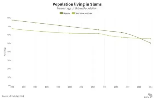
This is not the first time that the government has forcibly evicted waterfront communities in Lagos. Amnesty International has previously reported that such evictions are “in defiance of international law," with communities being “punished for the state’s urban planning failures.” While the number of Nigeria’s urban residents living in slum settlements has significantly declined since 1990, over half of that population still live in these communities.
In 2012, the government reportedly gave a 72 hours’ notice to evict the residents of Makoko. Authorities claimed the settlement constituted an “environmental nuisance, security risk and an impediment to the economic and gainful utilization of the waterfront" and undermined its "megacity status," according to reports.
Now, following the January evictions in the region, Makoko’s residents are once again scared they are next.
John Eromosele, the project lead at Code For Africa for the mapping project, says that the maps aim to help shift the conversation with the government about Makoko and its legitimacy as a city, but as a place with a lot of potential.
To map the community, the NGO trained young residents to pilot drones to capture aerial footage of the community and input map coordinates on an open source app on their mobile phones, to pinpoint roads and points of interest in the community.
“The maps are also useful for regional planning and to help determine population density in Makoko,” Eromosele said, adding that the project helps to cut down the work of the government and policymakers by providing the data they need for development planning. Because there has never been a census in Makoko, he explained that it is very easy for the government to suggest that the residents of Makoko, like other waterfront communities in Lagos, vacate their homes for highrise housing projects.
But armed with up-to-date maps, “there will be an estimation of population data as well as data on the quality and types of homes present in Makoko for future planning,” he said.
Panke agreed that the maps could have a potential positive impact. He said that the community currently manages and runs itself: there are no government schools or hospitals in Makoko, and they are not connected to the grid — everybody that has electricity owns a generator. Updated maps would allow the government and energy agencies or companies to connect Makoko to the rest of Lagos, he said.
Megacity Plans for Lagos — and Makoko
Slums like Makoko are not necessarily part of the vision for Lagos as a “megacity,” and do not measure up to the investment it intends to attract. But this vision contrasts with the reality in Nigeria: while these communities are demolished to make way for luxury properties, over half of the population lives below $1.50 a day, and the majority of Lagos’ residents are unable to afford the highrise homes that are now dotting the skyline.
To help make Makoko an integrated part of Lagos, Lookman Oshodi, the project director of urban development and infrastructure consultancy Arctic Infrastructure, led a team of volunteers in 2012 to create a Makoko/Iwaya Waterfront Regeneration Plan that targets affordable housing and multiple infrastructure in the community.
“We looked at Makoko as a single city and took several of its problems holistically…problems of health care, energy generation and distribution, sanitation, and even quality of housing, and we created a document that tackled the problems enumerated by the government and proposed improvements,” Oshodi explained.
“But there was no map to base our work on. This new mapping project better places our plans on a real-life dashboard to track our progress and see what we can improve on.”
A Buckminster Fuller Award finalist, the plan addresses the aesthetics of Makoko while keeping it affordable for the people that reside in the community. The multipurpose nature of the plan makes it a potential model for other waterfront communities still standing in Lagos and around the world.
But since the plan was submitted in 2014, nothing has been done, Oshodi said. However, he adds that whenever there are renewed attempts to evict the waterfront communities, the plan helps to rein the government in.
“In the event that the government comes to evict the community, the people can ask the government why the plan was not tested out,” he explained.
Now, the maps are extra ammunition for the community, and its existence is legitimized by its presence on digital maps.
“The new map will hopefully force a new conversation about Makoko. There is a plan for [its] development, and demolishing the community and evicting the thousands that live there will be devastating,” Oshodi explained.
“The maps can help restart the conversation about the development of Makoko and its potential,” he said. Makoko is extremely important to the city of Lagos, he added, as it and some of the other demolished waterfront communities are better suited to deal with the effects of climate change and rising sea levels than the rest of coastal Lagos.
“Over the years, these communities have had to adapt and evolve to deal with floods and the changes in water level,” he said.
Community-wide Support
While the tight-knit community is wary of external players in their space, the five chiefs of Makoko are on board and have sold the idea to the residents. “If we can do anything to stop the government from evicting us, we will,” Panke said.
According to Code for Africa’s Eromosele, the maps for Makoko are just the beginning. “We are hoping to move to other waterfront communities. The technology for the map is online and is open source. We are hoping more people decide to join up and digitize their communities.”
And for Zunze, the mapping project is a lifeline. “The people of Makoko took us in and are helping us with a more permanent space. We are hoping that Makoko works because there are so many people that do not know any other life apart from here,” he said.
Reporting for this story was supported by the Pulitzer Center on Crisis Reporting. However, Devex maintains full editorial control of the content.
Visit the Data for Development series for more coverage on practical ways that satellite data can be harnessed to support the work of development professionals and aid workers. You can join the conversation using the hashtag #DataForDev.