Project
Cholera: A Tale of Two Cities
The cholera epidemic that hit Haiti four years ago bears some startling resemblances to one that...
Nearly two centuries separate the two epidemics—one began four years ago this month and the other in the summer of 1832—but they are otherwise strikingly similar, and the parallels offer some lessons for public health officials today. A novel infectious agent, cholera, is introduced into an island population living in crowded and unsanitary conditions, killing thousands. The recent epidemic, of course, occurred on the impoverished island nation of Haiti. The earlier one unfolded 2,400 kilometers north, on the island of Manhattan. With narrative, interactive maps, "Mapping Cholera: A Tale of Two Cities," provides a look at the searing pathways of two outbreaks.
The waterborne bacterial pathogen that causes cholera, Vibrio cholerae, most likely arrived in Haiti with United Nations peacekeepers from Nepal, whose camp discharged sewage into a stream that fed into the nation's largest river, the Artibonite. The bacteria spread south to the capital city of Port-au-Prince, where dense urban crowds lacking reliable access to clean drinking water and sanitary systems were already reeling from a magnitude 7.0 earthquake that had hit in January 2010. Haiti had not been exposed to cholera for over a century—so the population had not acquired even limited immunity to infection. Within nine months, Haiti had more cholera victims than the rest of the world combined.
The international humanitarian nongovernmental organization Doctors Without Borders (MSF) spearheaded the international response to the epidemic in Haiti, treating more than half the reported cases. "Mapping Cholera" uses the GPS data collected by MSF on thousands of cases, along with several years' of reporting that I have conducted to document the Haitian epidemic from 2010 to 2014. During that time period, more than 700,000 Haitians fell ill and more than 8,000 died.
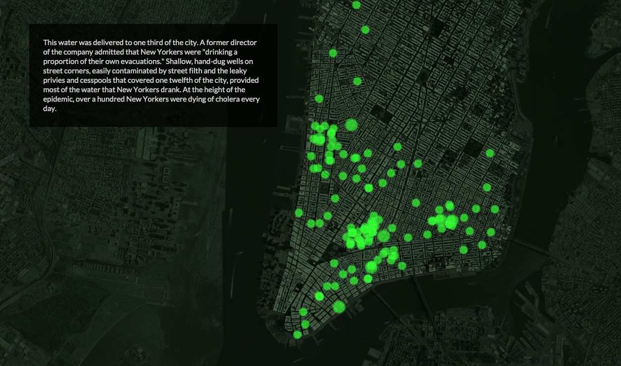
In 1832 cholera arrived in Manhattan via the Hudson River and the newly opened Erie Canal. In the slums at the epicenter of the outbreak population density was nearly six times greater than it is today. The disease sickened 5,800 New Yorkers—more than 2 percent of the city's population—and killed nearly 3,000.
With a narrative by science journalist Sonia Shah and interactive maps produced by the Pulitzer Center's Dan McCarey, the interactive provides a look at the searing pathways of two outbreaks. To view the full article and the interactive "Mapping Cholera A Tale of Two Cities" in Scientific American, please click here.
The map is now available to embed for free, everywhere.

Education Resource
Telling Science Stories: Data Visualization
This video interview was developed specifically for our Global Health Lesson Builder Initiative...