Story
 July 15, 2022
Investigating Rainforest Destruction: Tracking Philippine Nickel Mines to U.S. Car Batteries
Country:


Karol Ilagan, a director at the Philippine Center for Investigative Journalism, is investigating...
The Rainforest Investigations Network (RIN) has asked its 2021 Fellows about the innovative methodologies behind their impactful stories.
From Freedom of Information requests to analyzing satellite imagery with AI, the reporters uncovered data that shed light on the corruption and systems behind the destruction of the world’s biggest rainforests. Read the Investigating Rainforest Destruction series to learn how they did it.
RIN Fellows Karol Ilagan and Andrew Lehren brought together their outlets, the Philippine Center for Investigative Journalism (PCIJ) and NBC News, to uncover the supply chain that is feeding nickel mined from Philippine rainforests into U.S. car battery production.
For six months they worked together closely, sharing documents and sources. Sometimes, Lehren would wake up in the middle of the night to join Ilagan to interview experts and government officials in the Philippines, which is 12 hours ahead of New York.
The stories were published on the NBC website and as a TV documentary on the NBC Nightly News show, reaching millions of American viewers. PCIJ published the investigation as a series called Losing Paradise, with maps, interactives, and other data visualizations.
Half a year later, the joint investigation won the SPJ Dateline Award for Television Business Reporting, the Headliner Environmental Writing Award, and the SABEW Energy/Natural Resources Best in Business Award. The reporters were also listed as finalists for the Sigma Awards and the Deadline Club Business Investigative Reporting Award.
Their collaboration was an RIN first and showed the impact that can be generated when local investigative experts work together with international broadcasters. Ilagan and Lehren explained to the Pulitzer Center how they uncovered this international trail, which data they found, how they analyzed it, and how they overcame challenges in collecting the information.
How Data Supported the Story
Pulitzer Center: Can you tell us about the role data played in your reporting?
Andrew Lehren: Data was integral. We wanted to connect rainforest destruction with what is happening in the U.S. and European markets—how those economic forces were in part responsible for rainforest loss.
Karol Ilagan: Three key datasets provided the backbone to the PCIJ and NBC collaboration.
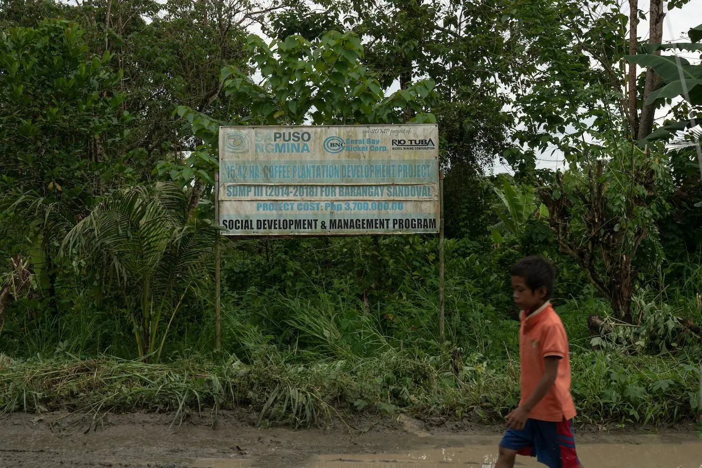
First, we needed to track where nickel from the Rio Tuba mine in Palawan ends up. This was crucial to the collaboration as we were looking for connections between countries. We had some initial leads that nickel from the Philippines is being used in Tesla batteries, but we didn’t have information on the source mines. Finding out about Tesla encouraged us to look into the issue primarily because of how it is touted as a green car and how the demand is growing. By then, mining in the Philippines has had a long history of environmental destruction. Palawan is the latest flashpoint.
Ultimately, we hoped that understanding where our minerals go and how they are consumed could draw attention to how the transition to clean energy is coming at a high cost to forests, rivers, and people in a poor country like the Philippines, and in the country’s last ecological frontier no less. In the course of research, both people and paper trails led us to confirm the lead we had.
Now to explain further what’s wrong or unjust about the whole issue, we needed to figure out whether standards were followed in the Philippines and how the host community is being impacted. Timing was crucial here too as [the Rio Tuba mine] is just about to expand on Mt. Bulanjao, and this, we later found out, is due to the high demand for nickel for electric vehicles. The issue of rezoning was at the core here, so we needed to track the revisions of the environmental zoning maps, which eventually led to Rio Tuba being allowed to expand on a pristine mountain.
Lastly, apart from exposing these issues, we wanted to make sure that we highlight the state of the community and how they could be further affected by the expansion. For this aspect, we went back to previous reports and found out about the high levels of hexavalent chromium in Rio Tuba waterways. Hexavalent chromium figured in the Julia Roberts film Erin Brockovich, in which an energy company was found polluting the water in Hinkley, California.
The work done by Friends of the Earth Japan (FoE Japan) was already comprehensive, testing the waters annually until 2019, or before the pandemic hit. But we decided that we had to do our independent testing to get latest and current results and to prove that the contamination persists.
PC: What data and information did you end up using in your investigation?
KI: The supply chain data that proved that nickel from Rio Tuba is being used in batteries of Tesla cars and other electric vehicle (EV) automakers.
AL: To understand the companies, we needed to understand those involved in the supply chain. No supply chain was direct. Each involved several companies before they reached U.S. shores. Corporate databases like the filings in SEC EDGAR and analogous ones overseas provided key documentation.
We used mapping data to examine proposed destruction of a pristine rainforest in the Philippines.
KI: For that we used a mining expansion map that we overlaid with a satellite image of the area, environmental zoning maps, and water quality analysis results.
Whistleblowers and others in possession of sensitive information of public concern can now securely and confidentially share tips, documents, and data with the Pulitzer Center’s Rainforest Investigations Network (RIN), its editors, and journalists.
Where to Find Supply Chain and Environmental Data
PC: How did you obtain the data? Did you use any tools?
AL: For the shipping data [to track the supply chains], Panjiva and ImportGenius were the two most useful commercial shipping data sets, though we explored others. We also used a wide range of OSINT tools to locate images, find corporate PowerPoint images and sale pitches. We OCRed all documents for text searchability.
KI: We obtained the supply chain data that proved the nickel went to car batteries from company filings and shipping records, and verified it through interviews with the companies themselves and groups that are monitoring the supply chain in Japan.
Our lead initially came from a Japanese NGO, which shared with us Sumitomo company filings and press releases about its supply chain. We then complemented this by looking further at filings of the companies involved (Rio Tuba, Nickel Asia, Sumitomo, Tesla, and other EV manufacturers) as well as shipping records. We also interviewed and/or requested comments from the companies.
We obtained the map that shows Rio Tuba’s current site and expansion site from the Mines and Geosciences Bureau through an official public records request.
Getting the environment zoning maps of Mt. Bulanjao was tricky because no single entity could provide us with all of the versions of the map. We needed to show how parts of Mt. Bulanjao have been rezoned from core (red) and restricted-use (blue) to controlled-use (green) where mining is allowed.
Where Karol Ilagan found the environmental zoning maps of Mt. Bulanjao
- 2006 ECAN map (shapefile): Downloaded from the online map portal of the National Mapping Resource and Information Authority (NAMRIA).
- 2014 ECAN map (image from a PDF): Obtained from the Environmental Impact Statement of Rio Tuba, which was submitted to the Environmental Management Bureau.
- 2021 ECAN map (image from a scanned paper file): Obtained through a public records request with the Palawan Council for Sustainable Development. It initially declined our request, saying the map is being updated. The council provided us with a copy after an interview.
PC: Can you tell us more about the water quality analysis results and how you verified them?
KI: FoE Japan provided us with a copy of their annual testing reports since 2009. The group could not continue their annual testing in 2020 and 2021 because of travel restrictions brought on by the COVID-19 pandemic. To check if the contamination persisted, we conducted our own sampling and testing in October 2021. I took water samples during the field work, which we then brought to Manila for analysis.
We also sought the guidance of a toxicology professor and a chemistry professor. The chemistry professor is the head of the laboratory where I sent the samples. For sampling parameters, we referred to the government’s Water Quality Monitoring Manual.
PCIJ’s testing, which used on-the-spot detector kits and laboratory analysis, confirmed FoE Japan’s findings as well as two quarterly tests conducted by the government in 2020. The levels of hexavalent chromium indeed exceeded Philippine water quality and World Health Organization standards.
Analyzing the Data and Challenges
PC: How did you process the data? What tools did you use?
KI: We used Microsoft Excel to analyze the shipping records and the water testing results and used QGIS to analyze the expansion map vis-à-vis satellite imagery of Mt. Bulanjao and the current mining site.
We also used QGIS to analyze the changes in the ECAN zoning over three periods. This was crucial to illustrate what authorities did to allow the expansion to happen.
AL: For mapping, we used QGIS, ArcGIS, Google Earth Pro, and the tools that come from Landsat and Planet Labs. We got a big assist and help from Ed Boyda at Earthrise.
For data, it was mostly spreadsheets, though we also did some analysis work using database managers.
PC: What was the hardest challenge in the data work? How did you overcome it?
AL: Satellite imagery work can have a lot of uncertainty. That was hard. Working closely with Ed Boyda was very helpful. What was also hard was connecting the supply chain in each of these stories. That was countless hours of re-tracing each step and fully understanding how the supply chain worked.
KI: Generally, getting the records proved difficult. It took us a couple of months to pin down the Tesla connection. I completed the ECAN maps only after the interview with PCSD.
What helped us get the records is by following the paper trail or identifying which people or agencies or entities might have a copy of the records because they are part of the process. For example, we got the Tesla lead from a Japanese NGO which was monitoring Sumitomo.
Philippine authorities did not maintain shipping records. Andrew Lehren got the shipping records from Panjiva, but we couldn’t identify yet which mine the nickel was coming from. Japan ultimately became the link between the Philippines and the U.S.
In the process of doing the paper trail we were in effect doing the verification as well. This, I think, often becomes the most difficult part of an investigation. We finalized the verification by asking for or checking out more relevant records and interviewing more people.