Pulitzer Center Update July 27, 2020
Behind the Story: Jacopo Ottaviani, John Eromosele on ‘Mapping Makoko’
Country:


Project
Mapping Makoko
Makoko, one of the most crowded slums in Lagos, Nigeria, is finally being mapped—a project...

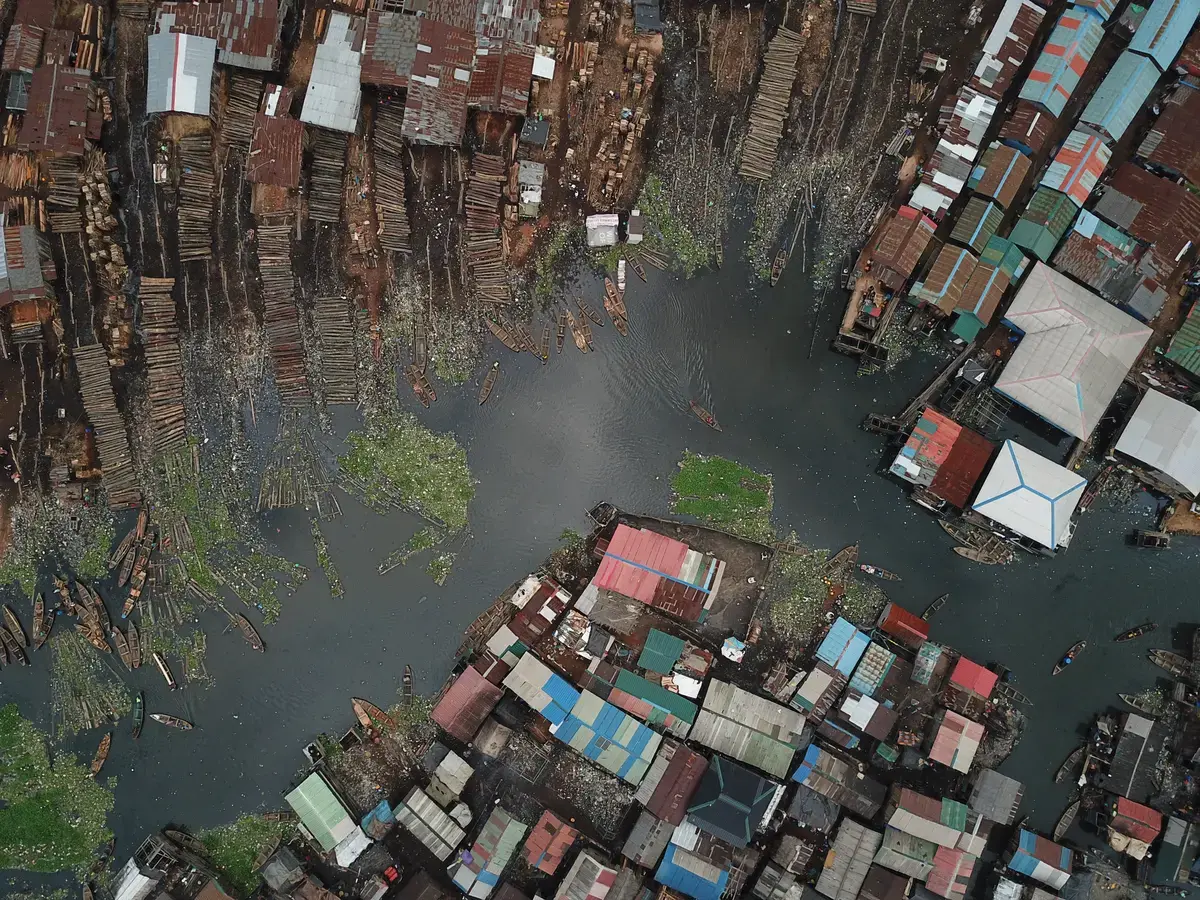


Just off the mainland of Lagos, Nigeria, lies a lagoon that is a near-blank space on most maps. Yet if you were to travel there in person, you would find Makoko, a floating community home to over 300,000 people who live, work, and pray atop the slum's wooden stilts.
Despite its density of human activity, Makoko's absence on maps makes it nearly impossible to plan infrastructure, public services, or emergency responses. In 2019, Code for Africa (CfA), a nonprofit technology and data journalism initiative, decided to change that. Their Pulitzer Center-supported project "Mapping Makoko," utilizes a wide array of technology and multimedia journalism to map the community and tell its story to the world.
"We appreciated this proposal's unique blend of technology use and reporting—drones, satellite imagery, as well as citizen journalists on the ground to highlight the problems of tenure insecurity faced by the Makoko settlement," Pulitzer Center Senior Strategist Steve Sapienza commented. "The project simultaneously raised the profile of the tenure insecurity and contributed data and imagery that literally put people, businesses, and other vital services on the map in a way that city leaders cannot ignore."
The following is an edited transcript of a Q&A between grantee and CfA Chief Data Officer Jacopo Ottaviani, CfA Project Manager John Eromosele, and Pulitzer Center General Intern Ethan Ehrenhaft. Portions of this text have been revised for clarity and/or length. Links have been included to digital tools used by CfA to build their project. Visit Open Street Map to view the Makoko map.
On the History of Makoko
John Eromosele: Makoko is a community that started off as a fishing settlement. Most of the fishermen were coming to the area from Badagry, from Benin, from the southern parts of Nigeria. They would all come together, fish, then go back home. At some point, they settled and fished for some days before they went back home so they could make more money out of it. They gradually moved their families over.
That is why, if you look at the community now, there's a blend of language and history. It is an amalgamation of culture from Benin and some parts of Nigeria. The most prominent language they speak is called Egun, that's the lingua franca. Because people migrated from the Benin Republic, over 70 percent of them speak French. Some of them also speak Yoruba. Generally, some still try to speak Pidgin English. That's a default, local slang that cuts across many parts of Nigeria.
On the Mission and Goals of the "Mapping Makoko" Project
Jacopo Ottaviani: The project we made with Pulitzer, MapMakoko, combined different approaches, such as geojournalism and mapping, with the aim of creating impactful journalism. The project itself also had a training objective, meaning that we wanted to train local activists, journalists, and citizens to use data and drones and map their own territory, with the idea that this kind of initiative would feed journalism. That's what happened, because we got a lot of media coverage.
The idea was that we would map the place using drones and data to create an open source map. By doing so, and by working with journalists who were putting these new maps into their stories and talking about the problems that the people [in Makoko] have, we would create quality journalism and raise awareness around land rights in Lagos.
JE: What [Code for Africa] does is we provide data to solve common social problems. We look at communities and social issues around them and see how we can use technology to provide solutions. Makoko came under our spotlight when we noticed that it is a community of over 300,000 residents. But on any official map we looked at, it was just being represented by dots. That says a lot, because for planning purposes it means they will be underserved—even with government interventions, which are not very visible in the area.
We had to do feasibility studies, hold quite a number of town hall meetings and lots of discussions to see how we could support this community. We saw that for many of the challenges, we might not be able to provide direct solutions, but we can provide leverage for other partners to also to be able to provide solutions to this community.
On the Challenges Facing Makoko
JE: One of their challenges was a lack of recognition and identity by the international community and even the [Nigerian] government. Makoko was not being integrated with the "megacity" of Lagos. It was a part of Lagos that was not being recognized because it is a floating city, a floating community, on top of the lagoon. It was built with silt and mud. Most of [the community] is not even on the muddy part, they are on the water, floating.
The second challenge was having too many middle men. When people wanted to support Makoko, they actually did not know whom to contact, because they're not visible on any map. There're no detailed contacts of leaders in Makoko and or locations of where the heads of the communities are. The community has been complaining that lots of support that was coming to them was not trickling down. They also complained about a lack of access to standard amenities and building capacity. We looked at all of these [challenges] and said, "okay, how can we support them?"
The basics of all these problems, if you analyze them critically, is lack of primary data. Even if you want to do advocacy, or a campaign, or talk to the government, you will find that if you don't have evidence, if you don't do evidence-based journalism, you will not get attention and nobody will listen to you because you need to bring out the facts. You need to bring out that "yes, there are actually lots of people living in this community." That was why we did all of this.
On Partnering With the Local Community to Collect Data and Map
JE: We would not be able to achieve this if we did not carry the community along. That was one challenge for other projects that have been coming here. [Makoko] is usually very careful with projects they approve or endorse in the community. People just come and take pictures of them, then disappear into thin air after the project. But as we all know, mapping is a continuous process. You continue mapping, updating your points of interest, and carrying them along.
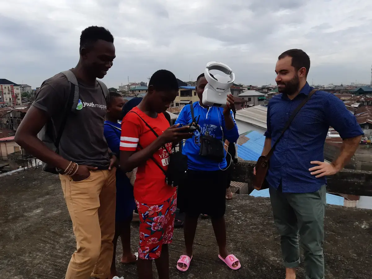
Irrespective of the funds we had, we were able to partner with key strategic partners that helped us support the project. We partnered with Uhurulabs, Makoko Dream, and the American Corner, which supported us with the space to have our physical trainings. That is how we engaged with [the community] and trained 32 persons on becoming drone pilots and mapping the area using the technology.
JO: I think it's worth highlighting that we didn't want to parachute in, make the project, and disappear. This Makoko community has seen many journalists and researchers coming there for two days and then do their story and disappear. We actually created a trust relationship with these people and we explained why we were doing all this.
After some long negotiations that John led very well with the local chiefs, we created this kind of trust relationship, and now we are welcomed there. They understood completely the philosophy of the project and endorsed the project. They even sent their children to attend our workshop and learn how to use drones to collect geographic data. We created an inclusive journalism process. We worked with a local community for a few months. If you google Makoko, you will find a lot of stories, but none of them have this kind of depth. And none of them rely on such a complex and long-lasting trust relationship.
On Combining Data, Technology, and Mapping With the Storytelling Process
JO: From the very beginning, we felt like Makoko is visually interesting from above. So we wanted to integrate and incorporate our drone shots into the stories. Most of the stories we published were high-definition drone shots.
Then we used videos. We collaborated with some filmmakers, along with the BBC and Agence France-Press (AFP). They sent out their journalists to take some footage and write their own stories. Our flagship story was a shorthand.com, long-form article, which was published by The Guardian in Nigeria. That includes everything we've mentioned, from the drone shots to the map. We also made data visualizations. We used a tool called flourish.studio, which is a data visualization tool to make charts. It's quite easy to use.
I understand it's a little bit of an unusual project because it combines many different things. But the idea is that when we create new data and new data visualizations and we make them accessible, these data and these visualizations can be used by journalists all over the world, as well as researchers and decision makers. Having this first series of stories was a little bit of evidence that when you create actionable data, you can feed journalism. Because data is a tool for advocacy, a tool to understand issues and to come up with solutions.
On the Impact of COVID-19 in Makoko and How Mapping Might Help
JO: In my opinion, the map makes sense, especially in these kinds of situations, to think about interventions and to try to understand how to manage a crisis like the current pandemic. Organizing interventions on public health in a place where hundreds of thousands of people live without a map would be almost impossible.
One of the intuitions behind the map was response to emergencies. We thought that the map could be useful in the case of climate crisis. With the rising level of the sea, these people will be facing huge problems. But also in a case like the COVID-19 pandemic, the map can be used as a tool by international organizations and also by the local government to organize support and distribute resources to the community. We also reached out to the Nigerian Red Cross, which works not far from Makoko, and we are in touch with them to see if they can use the map to organize their work.
JE: First of all, Makoko is a very clustered community, so COVID-19 would spread very well. The map that was created, it's open data. For now, we don't have access to the analytics to see who has used and visits the map. But like Jacopo said, it is meant for crisis use because we create maps in days of peace for emergencies. These are data that people can leverage and take advantage of, whether they reference us and give credit or not.
COVID-19 has made people lose lots of jobs in Makoko. I've been getting lots of calls on the challenges that COVID-19 has brought. People are not able to feed properly, they need support. But reports from the community have said that there was no government presence. But I think Makoko should be a starting point for the government and it is still not too late. COVID-19 is not over yet. Social distancing is the reason why we have not had a town hall meeting with them. What we'll have to do is share [resources] digitally through the local NGO, Makoko Dream.